
ACADEMICIAN EMIL DJAKOV INSTITUTE OF ELECTRONICS
BULGARIAN ACADEMY OF SCIENCES
72, Tzarigradsko chaussee blvd, 1784-Sofia, Bulgaria
LABORATORY LASER RADARS − LIDAR DATA
This work was supported in part by the Ministry of Education and Science of Bulgaria (support for ACTRIS BG, part of the Bulgarian National Roadmap for Research Infrastructure) and by the European Commission under grant agreements n. 262254 (ACTRIS), 654109 (ACTRIS-2), 739530 (ACTRIS PPP), and 871115 (ACTRIS IMP). |
 |
| Quicklooks Sofia lidar station, 42.65N, 23.38E, 550 m ASL |
||
|---|---|---|
| Lidar measurements, 2024 | ||
   |
Files:
sof_20240331120000_w1064_20km.png, sof_20240401120000_w1064_20km.png, sof_20240402000000_w1064_20km.png. |
Data type: Tot_Att_Backscatter. First measurement was taken on: 20240331, second measurement - on: 20240401, third measurement - on: 20240404. Spatial resolution: 3.5 m, Temporal resolution: 5 min . |
| Lidar measurements, 2023 | ||
            |
Files:
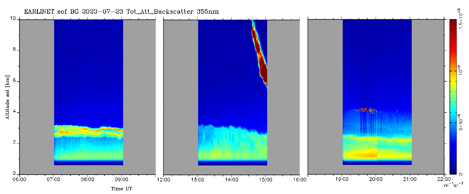
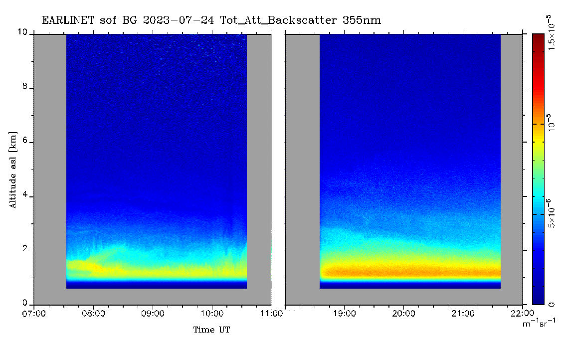
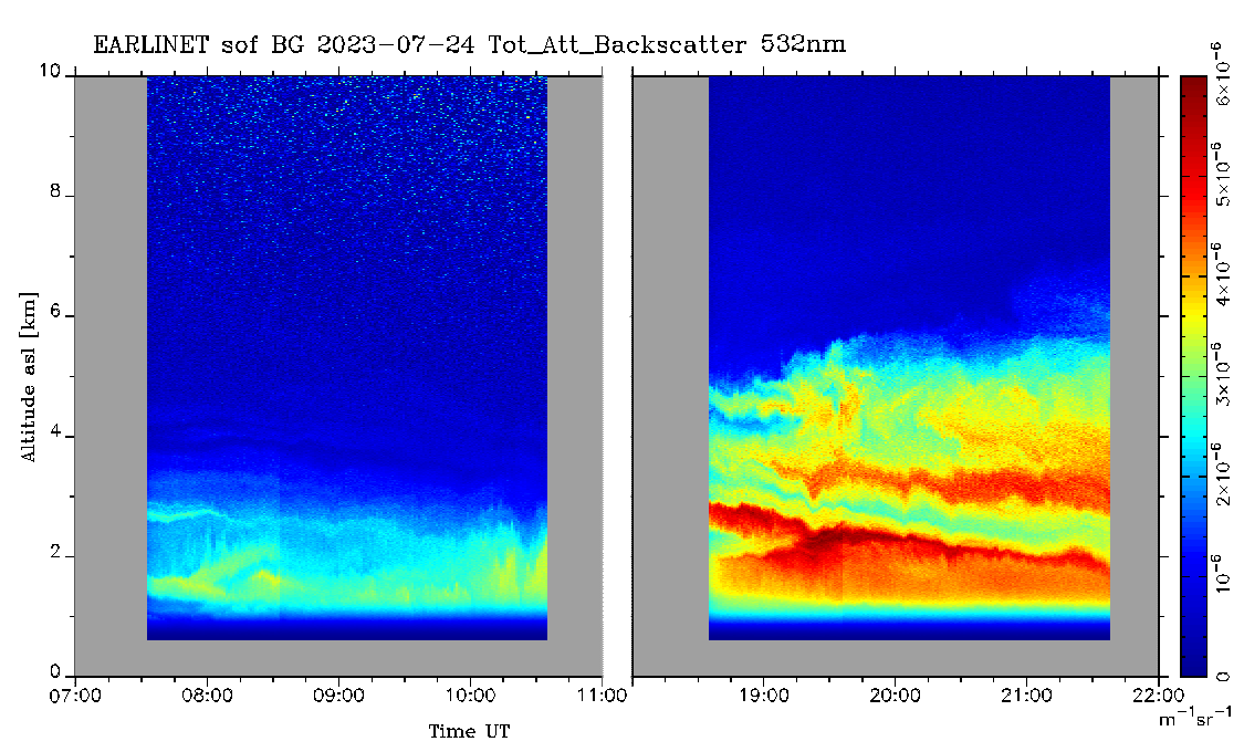
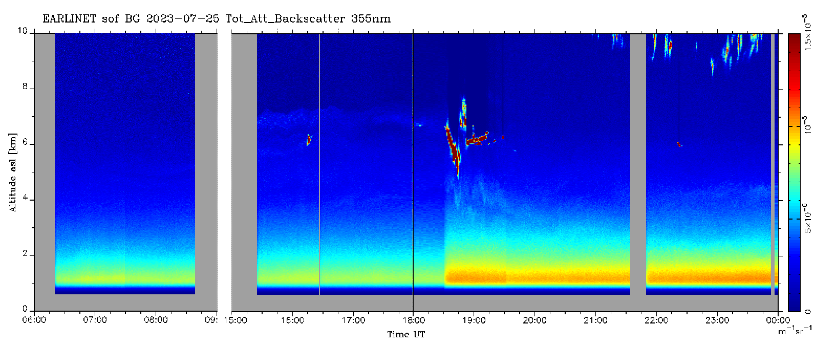
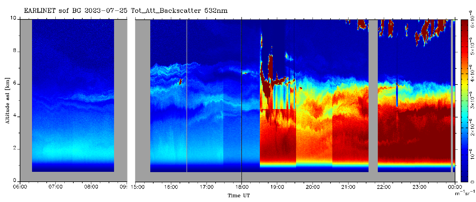
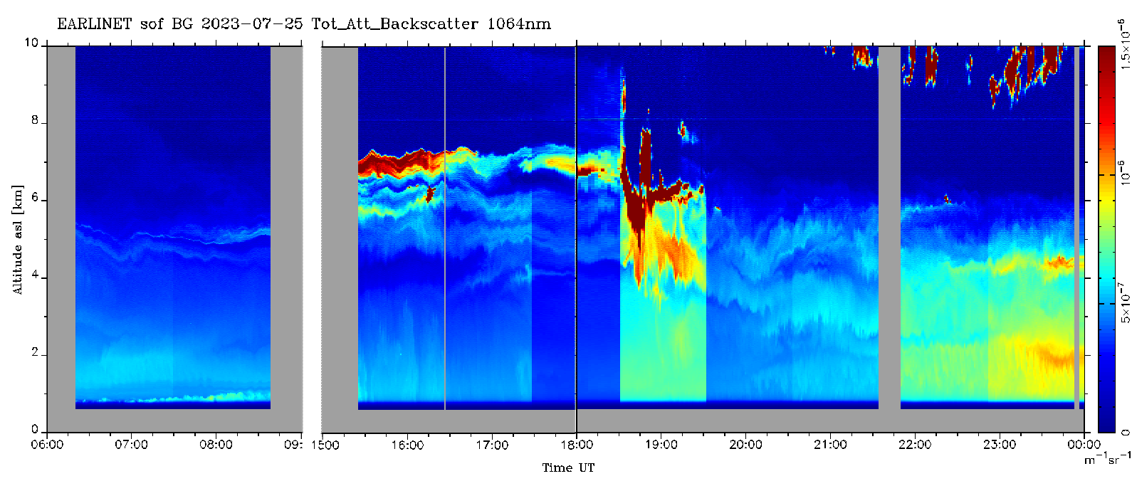
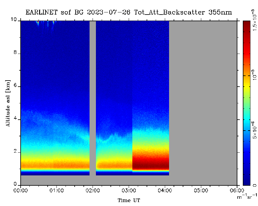
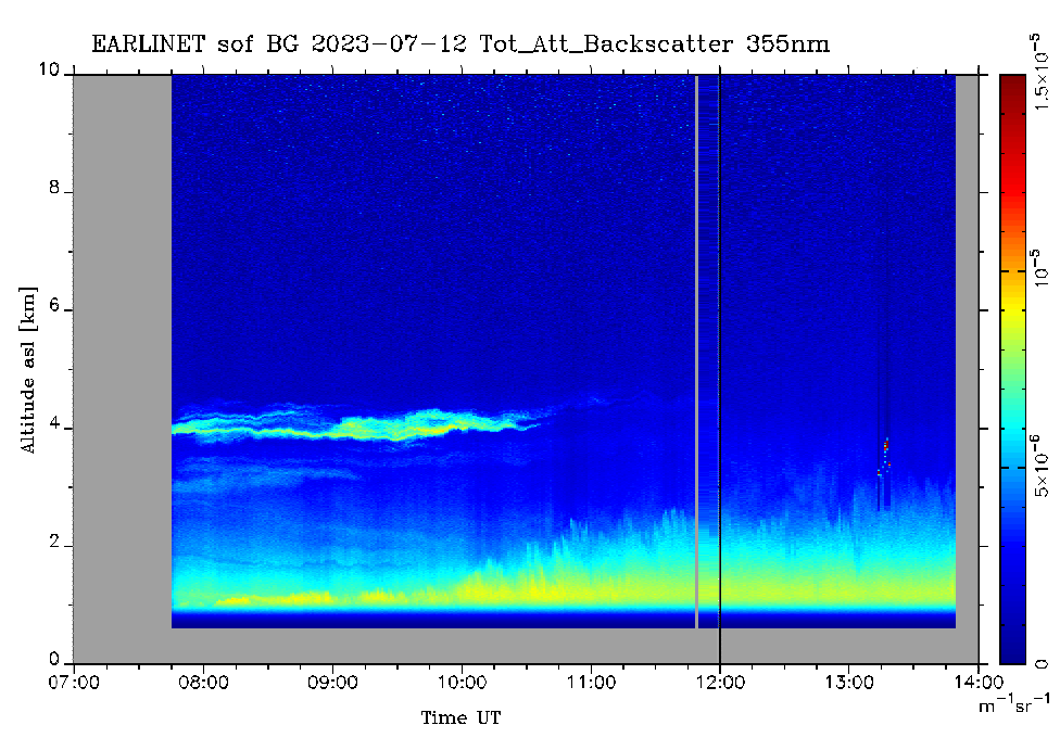
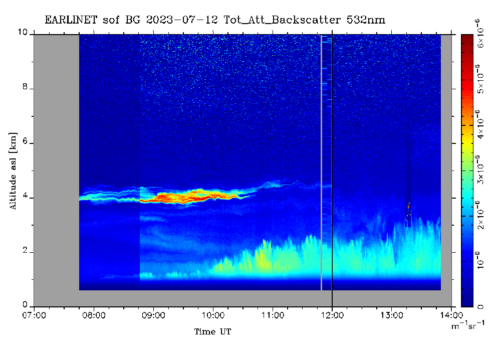
sof_20230723_06h355nm.png, sof_20230723_06h532nm.png, sof_20230723_06h1064nm.png, sof_20230724_07h355nm.png, sof_20230724_07h532nm.png, sof_20230724_07h1064nm.png, sof_20230725_06h355nm.png, sof_20230725_06h532nm.png, sof_20230725_06h1064nm.png, sof_20230726_06h355nm.png, sof_20230726_06h532nm.png, sof_20230726_06h1064nm.png. |
Data type: Tot_Att_Backscatter. First three measurements were taken on: 20230723, second three measurement - on: 20230724, third three measurement - on: 20230725, fourth three measurement - on: 20230726. Spatial resolution: 30 m, Temporal resolution: 5 min . |
                |
Files:
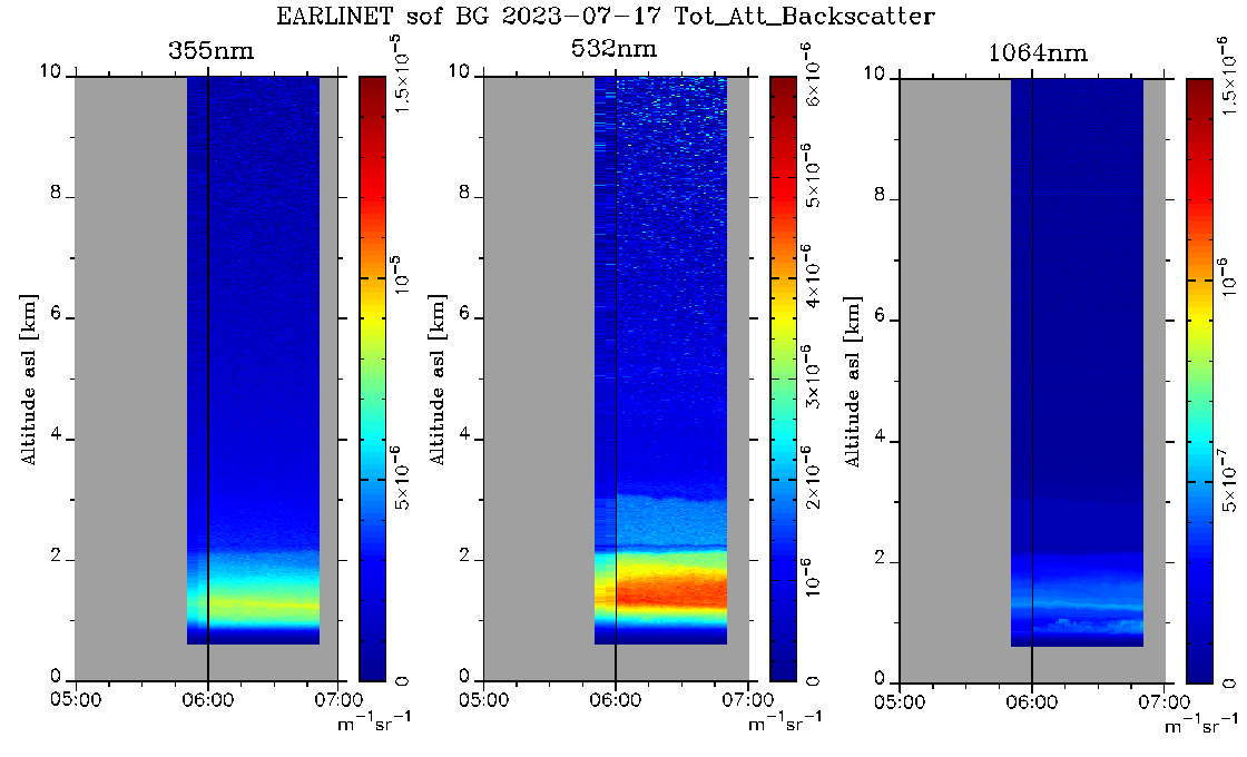
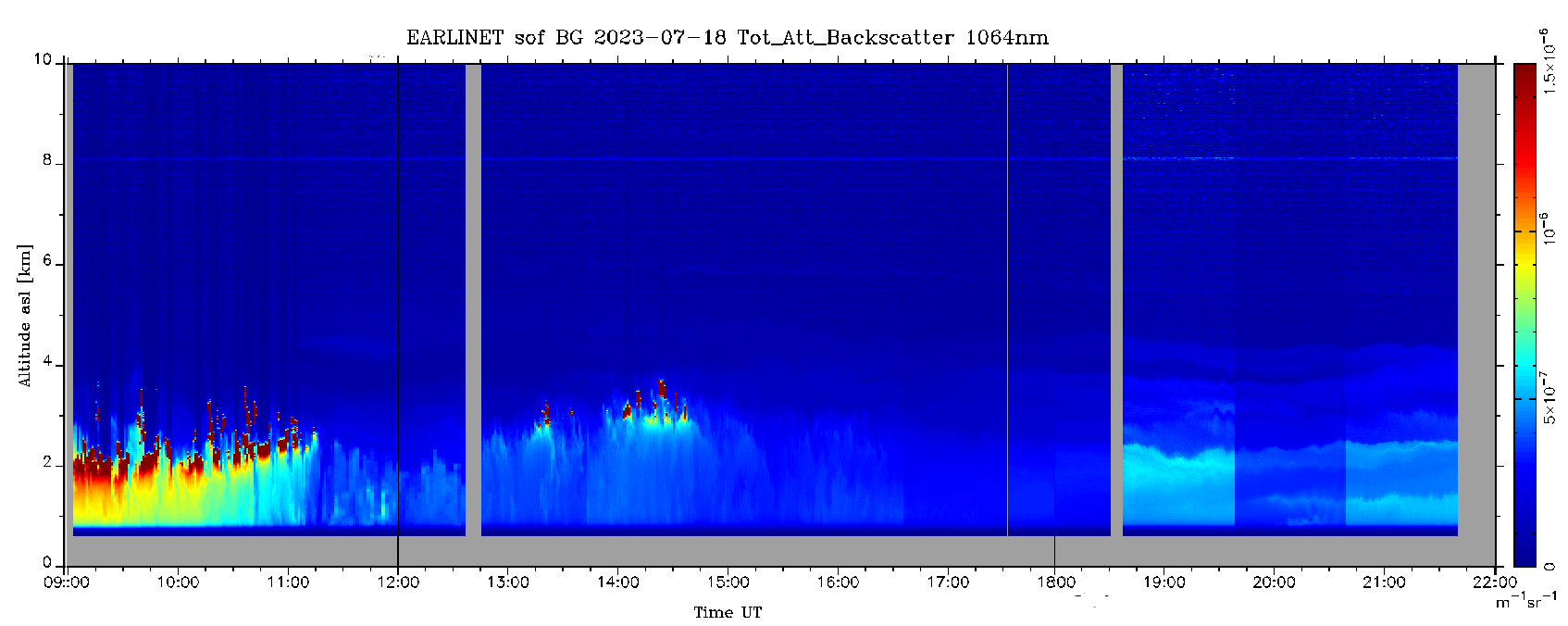
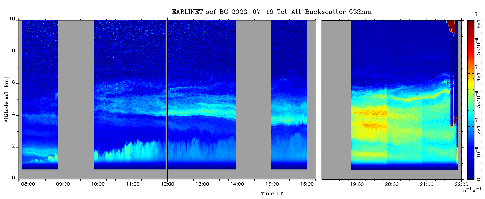
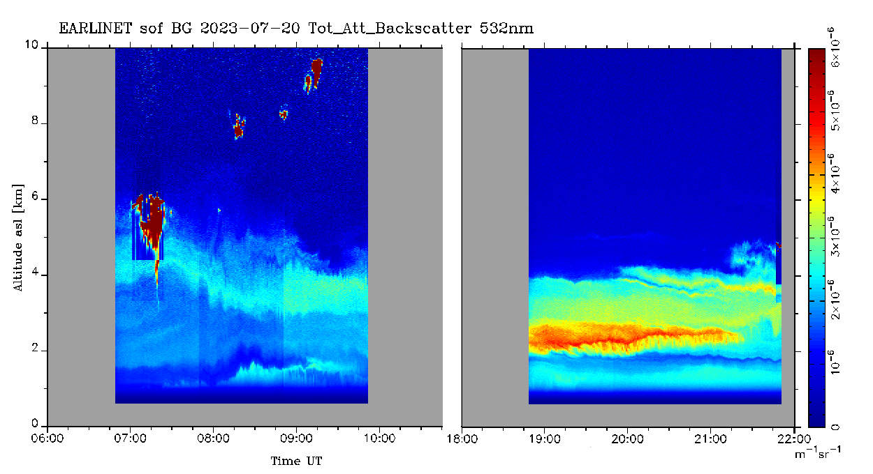
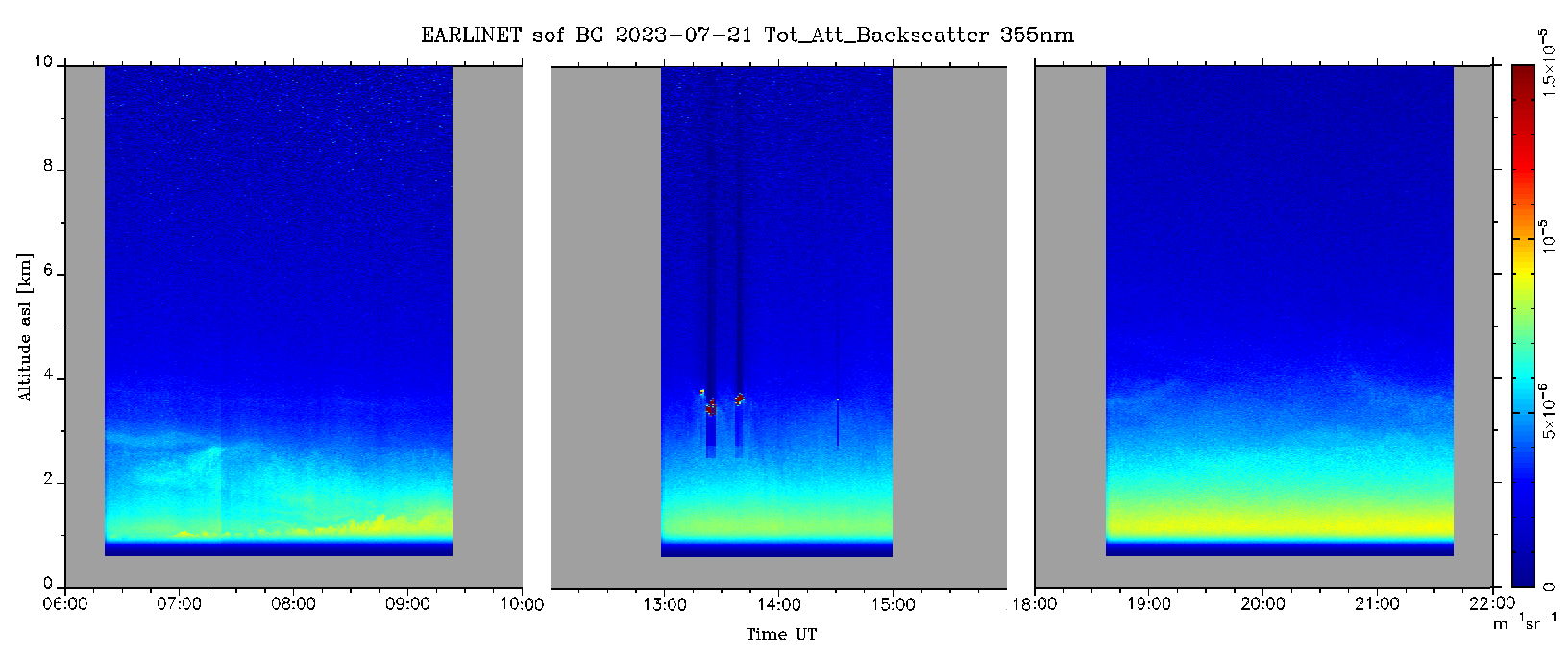
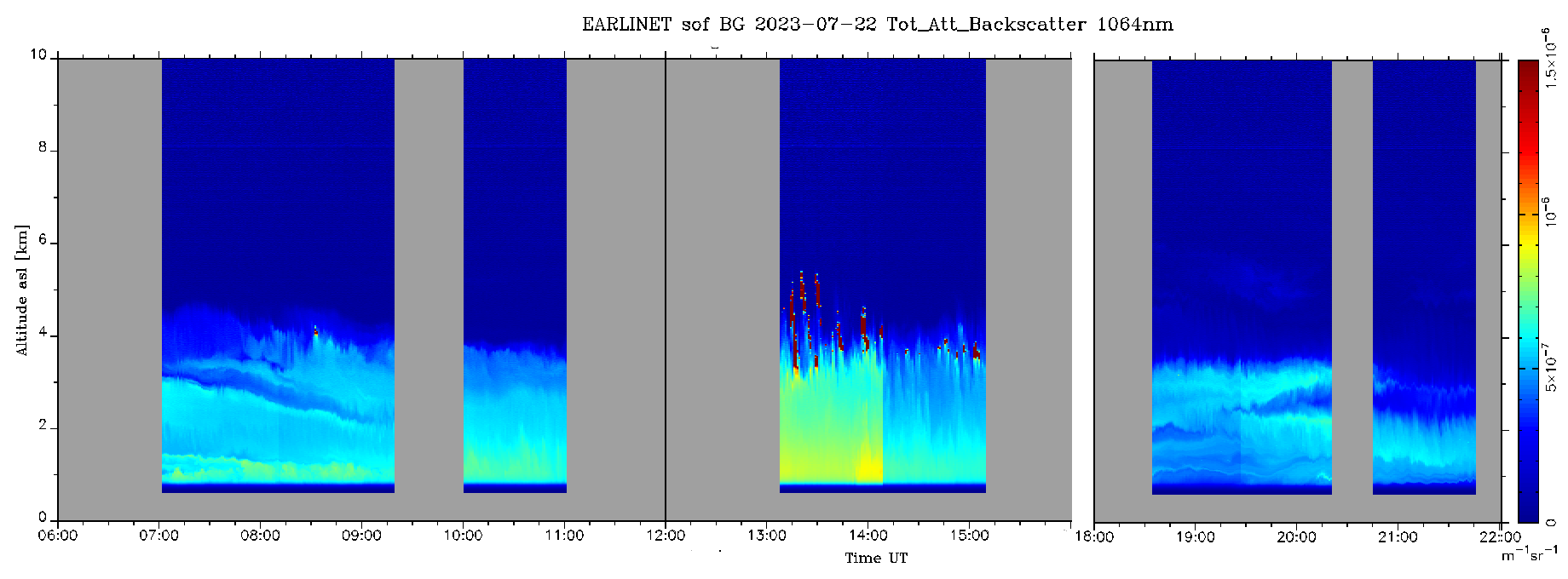
sof_20230717_06h_All.png, sof_20230718_06h355nm.png, sof_20230718_09h532nm.png, sof_20230718_09h1064nm.png, sof_20230719_08h355nm.png, sof_20230719_08h532nm.png, sof_20230719_08h1064nm.png, sof_20230720_06h355nm.png, sof_20230720_06h532nm.png, sof_20230720_06h1064nm.png. sof_20230721_06h355nm.png, sof_20230721_06h532nm.png, sof_20230721_06h1064nm.png, sof_20230722_06h355nm.png, sof_20230722_06h532nm.png, sof_20230722_06h1064nm.png. |
Data type: Tot_Att_Backscatter. First three measurements were taken on: 20230717, second three measurement - on: 20230718, third three measurement - on: 20230719, fourth three measurement - on: 20230720, ffifth three measurement - on: 20230721 and last three measurement - on 20230722. Spatial resolution: 30 m, Temporal resolution: 5 min . |
            |
Files:
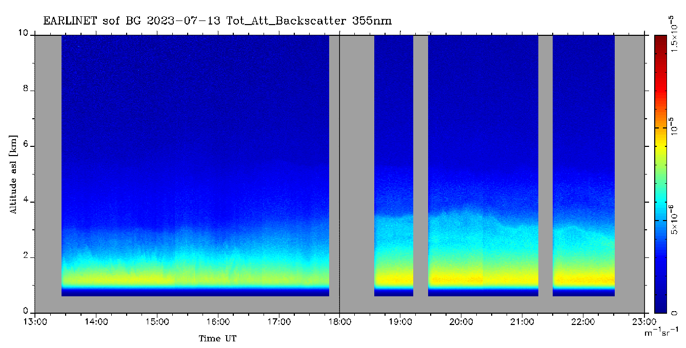
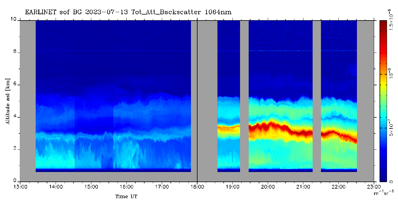
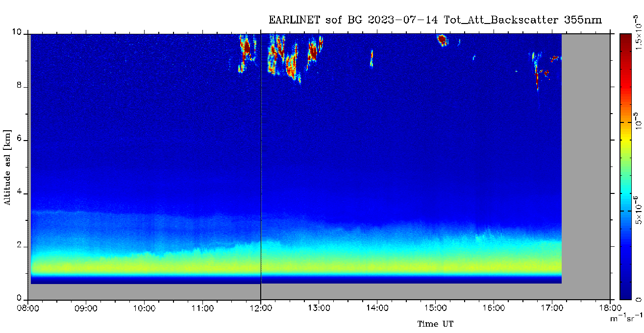
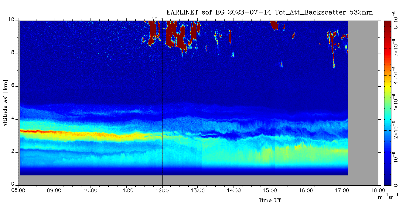
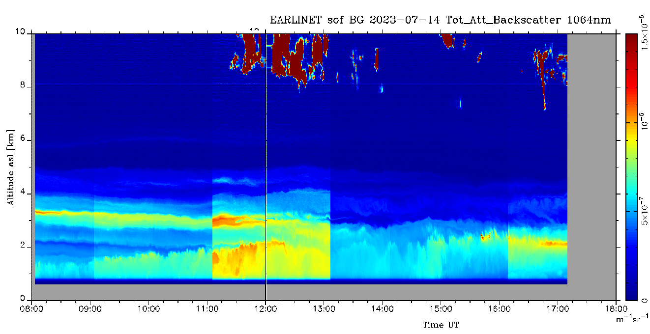
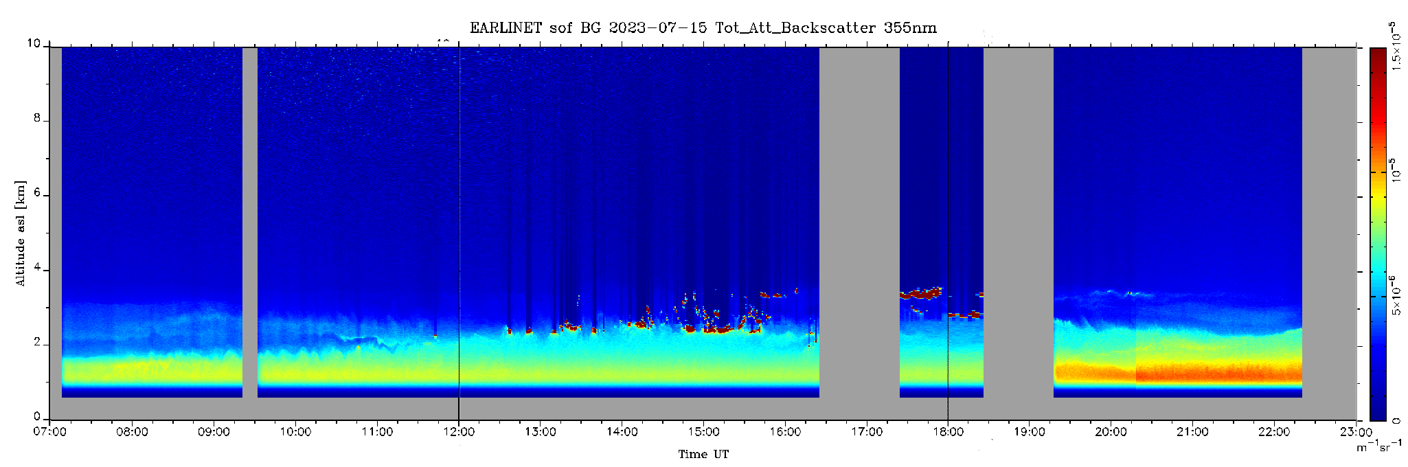
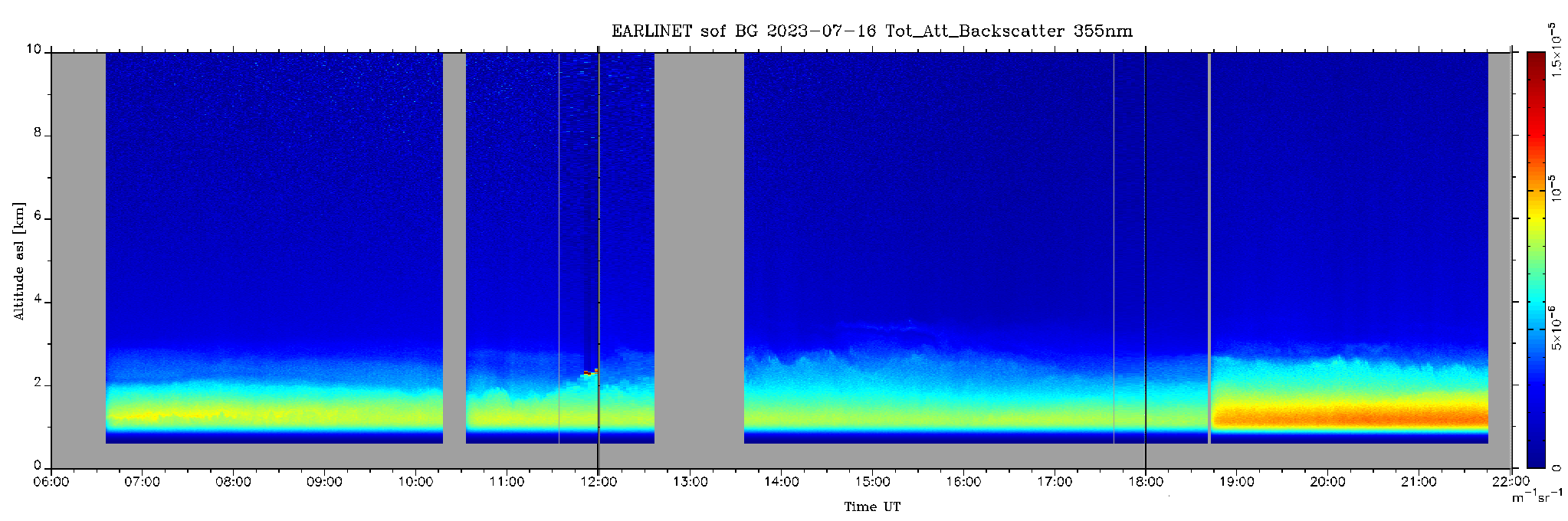
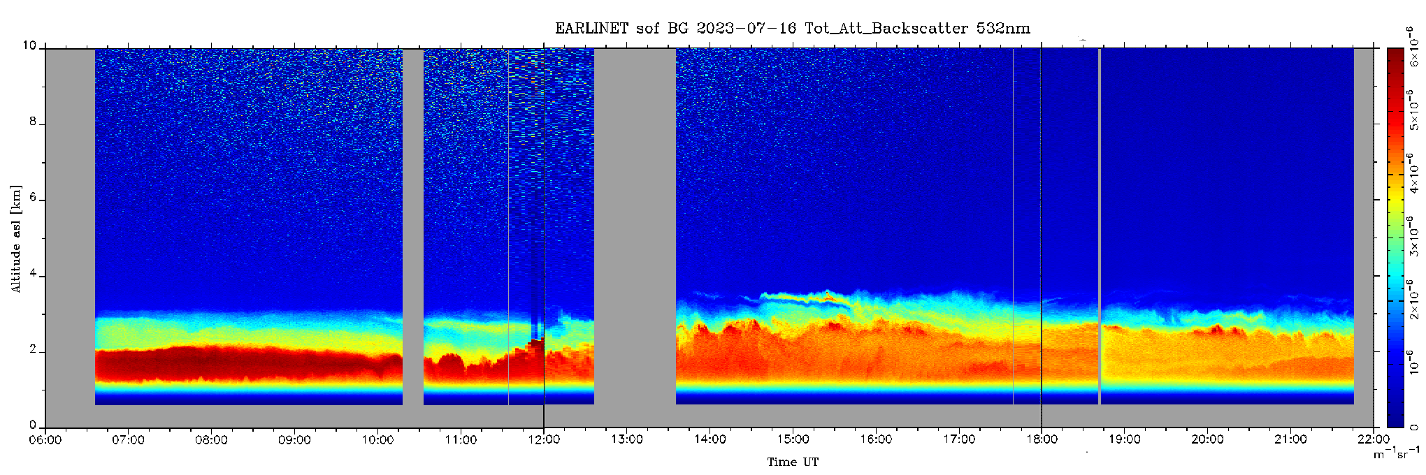
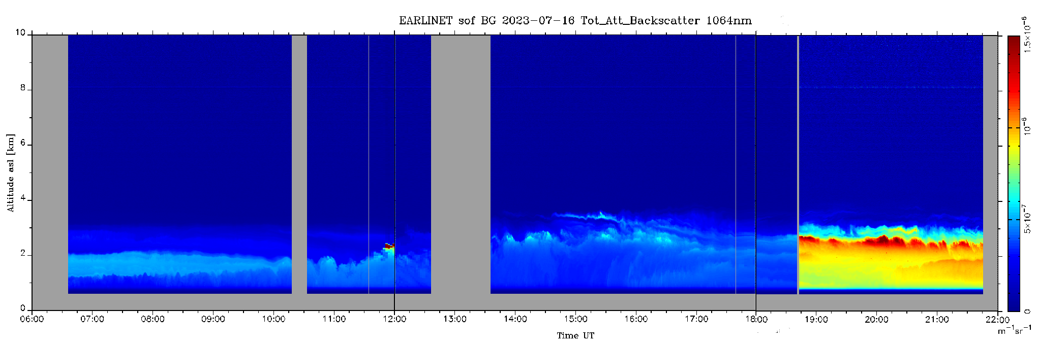
sof_20230713_12h355nm.png, sof_20230713_12h532nm.png, sof_20230713_12h1064nm.png sof_20230714_08h355nm.png, sof_20230714_08h532nm.png, sof_20230714_08h1064nm.png, sof_20230715_07h355nm.png, sof_20230715_07h532nm.png, sof_20230715_07h1064nm.png, sof_20230716_06h355nm.png, sof_20230716_06h532nm.png, sof_20230716_06h1064nm.png. |
Data type: Tot_Att_Backscatter. First three measurements were taken on: 20230713, second three measurement - on: 20230714; third three measurements - on: 20230715 and last three measurements - on 20230716. Spatial resolution: 30 m, Temporal resolution: 5 min . |
         |
Files:
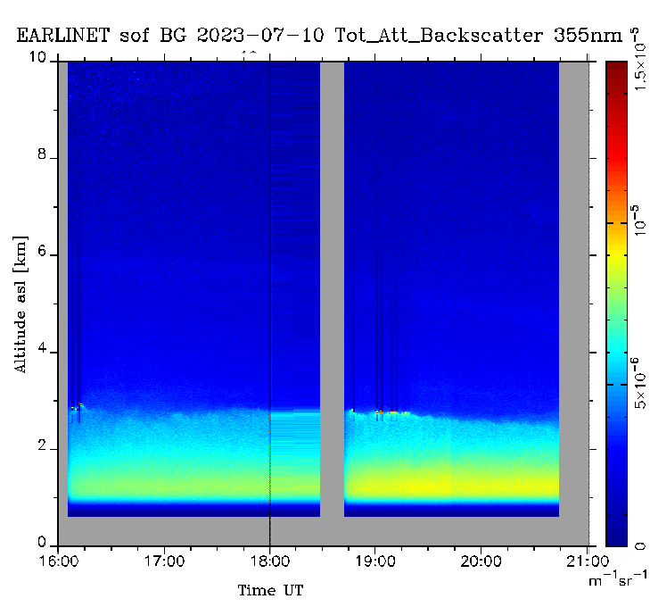
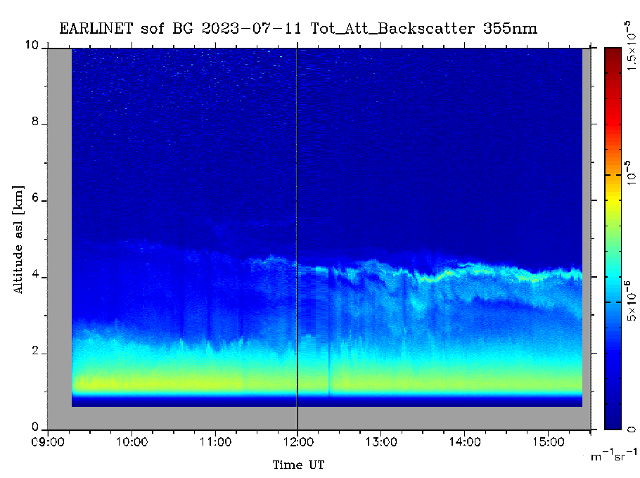
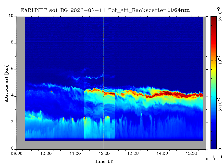
sof_20230710_16h355nm.png, sof_20230710_16h532nm.png, sof_20230710_16h1064nm.png sof_20230711_09h355nm.png, sof_20230711_09h532nm.png, sof_20230711_09h1064nm.png, sof_20230712_07h355nm.png, sof_20230712_07h532nm.png, sof_20230712_07h1064nm.png. |
Data type: Tot_Att_Backscatter. First three measurements were taken on: 20230710, second three measurement - on: 20230711; third three measurements - on: 20230712. Spatial resolution: 30 m, Temporal resolution: 5 min . |
  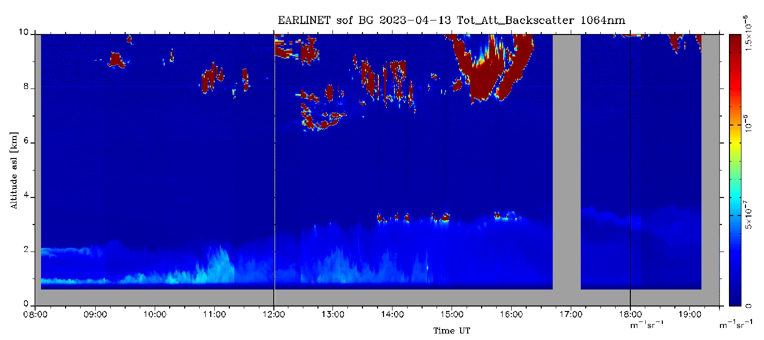   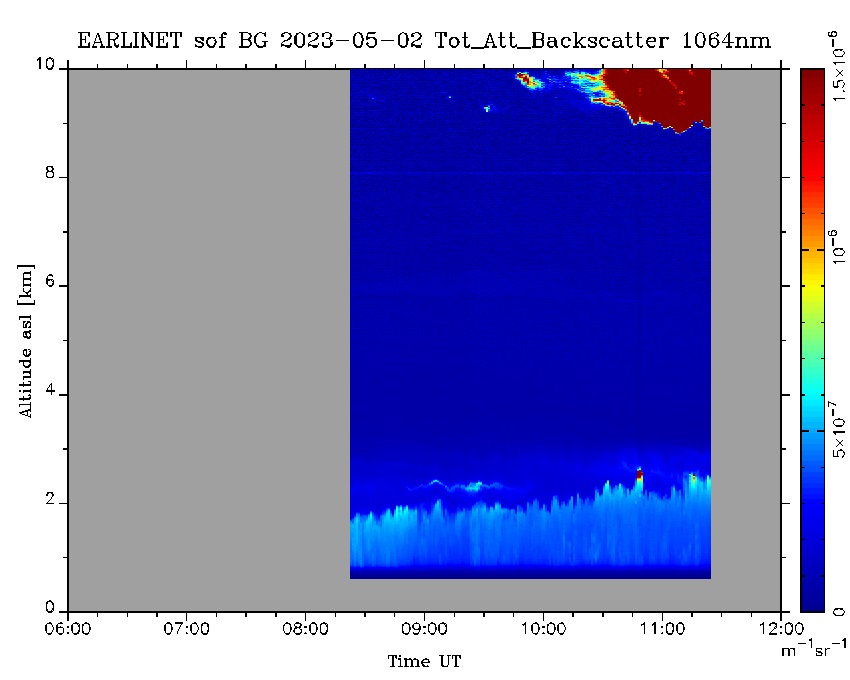 |
Files:
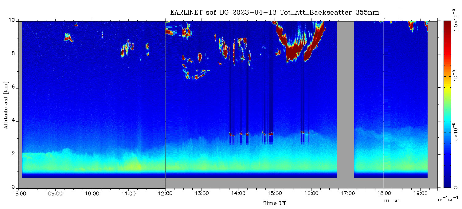
sof_20230413_08h355nm.jpg, sof_20230413_08h532nm.jpg, sof_20230413_08h1064nm.jpg sof_20230502_355nm.jpg, sof_20230502_532nm.jpg, sof_20230502_1064nm.jpg. |
Data type: Tot_Att_Backscatter. First, second and third measurement were made on: 20230413; forth, fifth and sixth measurement were made on: 20230502. (at 355 nm, 532 nm and 1064 nm). Spatial resolution: 30 m, Temporal resolution: 1 min . |
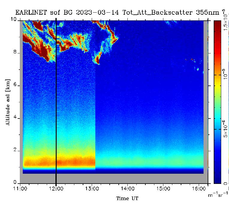 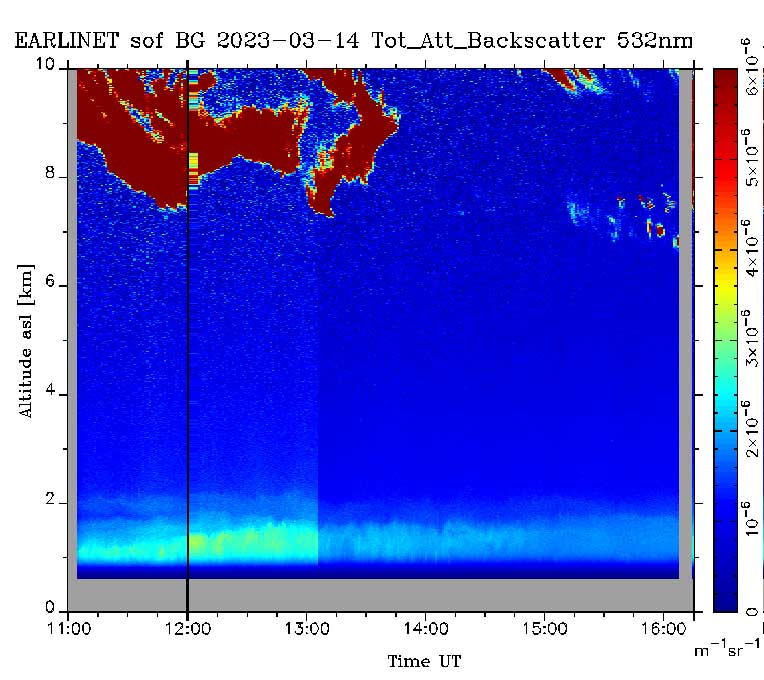 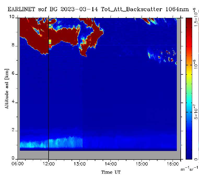 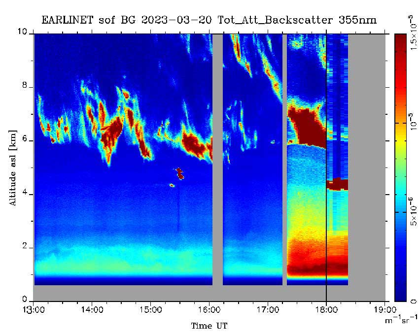  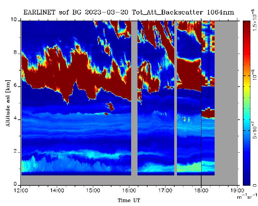   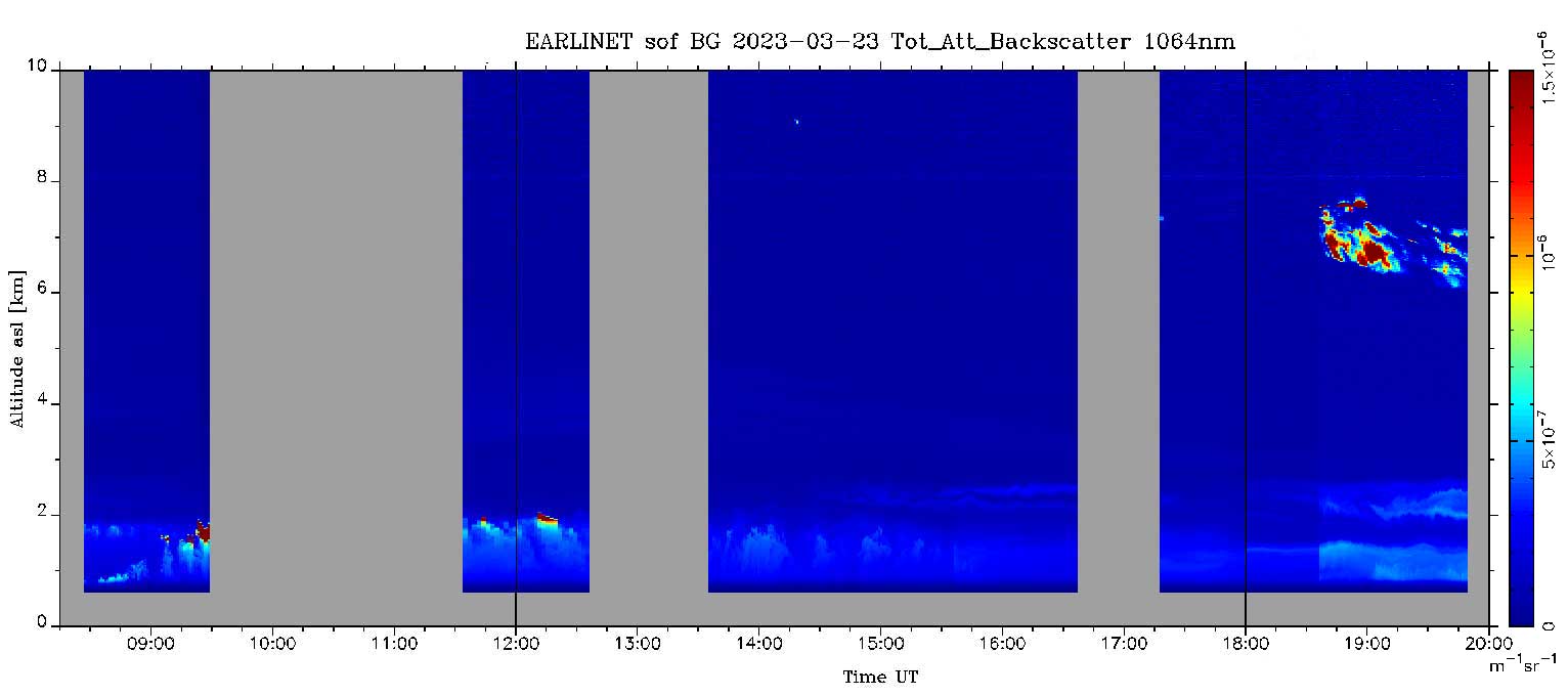       |
Files:
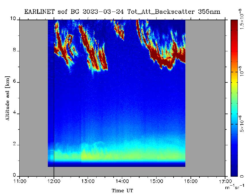
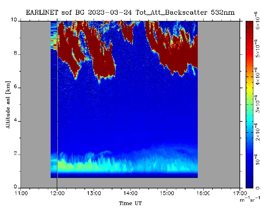
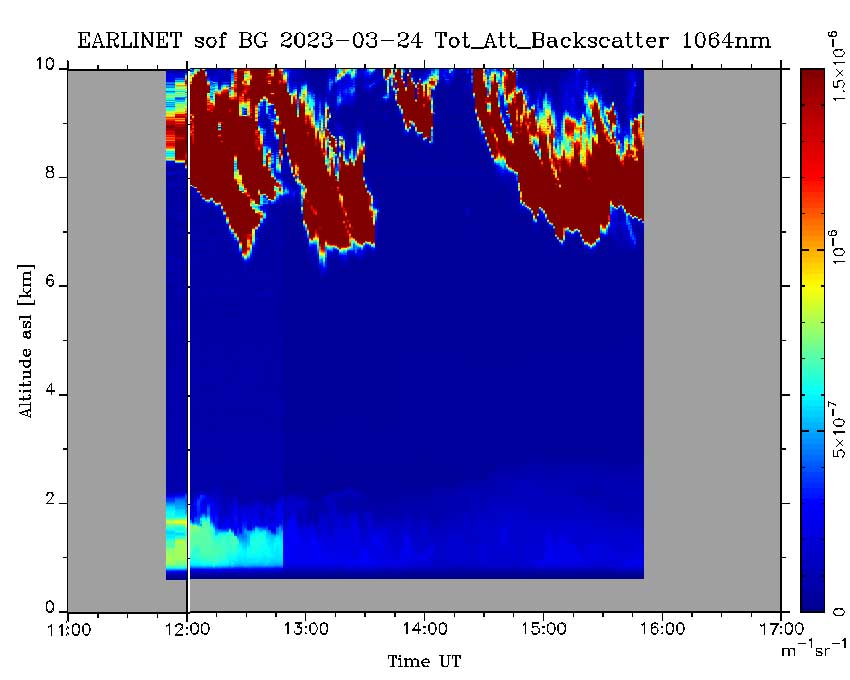
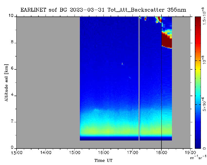
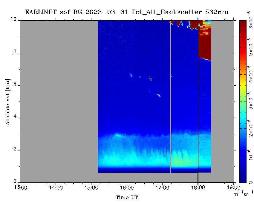
sof_20230314_11h355nm.jpg, sof_20230314_11h532nm.jpg, sof_20230314_11h1064nm.jpg, sof_20230320_13h355nm.jpg, sof_20230320_13h532nm.jpg, sof_20230320_13h1064nm.jpg, sof_20230323_09h355nm.jpg, sof_20230323_09h532nm.jpg, sof_20230323_09h1064nm.jpg sof_20230324_11h355nm.jpg, sof_20230324_11h532nm.jpg, sof_20230324_11h1064nm.jpg, sof_20230331_13h355nm.jpg, sof_20230331_13h532nm.jpg, sof_20230331_13h1064nm.jpg. |
Data type: Tot_Att_Backscatter. First measurement was made on: 20230314 at 11h-16h; second measurement was made on: 20230320 at 13h-18:30h; third measurement was made on: 20230323 at 09h-20h, forth measurement was made on: 20230323 at 12h-16h, fifth measurement was made on: 20230323 at 15h-18:30h. Spatial resolution: 30 m, Temporal resolution: 5 min . | Lidar measurements, 2022 |
         |
Files:
sof_20221107_12h-18h_All.jpg, sof_20221108_12h-18h_All.jpg, sof_20221109_06h-22h_355_1.jpg sof_20221109_06h-22h_532.jpg, sof_20221109_06h-22h_1064.jpg, sof_20221110_15h-18h_All.jpg, sof_20221114_11h-20h_355.jpg, sof_20221114_11h-20h_532.jpg, sof_20221114_11h-20h_1064.jpg. |
Data type: Tot_Att_Backscatter. First measurement was made on: 20221107 at 12h-18h;, second measurement was made on: 20221108 at 12h-18h; third (355nm), forth (532nm) and fifth (1064nm) measurements were made on: 20221109 at 11h-20h, sixth measurement was made on: 20221110 at 15h-18h, seventh, eight and ninth measurements were made on 20221114 at 11h-20h. Spatial resolution: 30 m, Temporal resolution: 5 min . |
      |
Files:
sof_20221101_09−16h_w0355.png, sof_20221101_09−16h_w0532.png, sof_20221101_09−16h_w1064.png sof_20221102_12−19h_w0355.png, sof_20221102_12−19h_w0532.png, sof_20221102_12−19h_w1064.png. |
Data type: Tot_Att_Backscatter. First, second and third measurement were made on: 20221101; forth, fifth and sixth measurement were made on: 20221102. (at 355 nm, 532 nm and 1064 nm). Spatial resolution: 30 m, Temporal resolution: 1 min . |
        |
Files:
sof_20221026_07−13h_w355.png, sof_20221026_07−13h_w532.png, sof_20221026_07−13h_w1064.png, sof_20221027_09−15h_w0355.png, sof_20221027_09−15h_w0532.png, sof_20221027_09−15h_w1064.png, sof_20221028_17h_19h.png, sof_20221031_15h_17h.png. |
Data type: Tot_Att_Backscatter ( at 355 nm, 532 nm and 1064 nm) First measurement was made on: 20221026, 355nm, second measurement was made on: 20221026, 532nm,, third measurement was made on: 20221026, 1064nm, forth measurement was made on: 20221027, 355nm, fifth measurement was made on: 20221027, 532nm, sixth measurement was made on: 20221027, 1064nm, seventh measurement was made on: 20221028 and eighth measurement was made on: 20221031. Spatial resolution: 30 m, Temporal resolution: 1 min . |
        |
Files: sof_20220603_11h-13h.png,
sof_20220712_14h-17h.png, sof_20220718_15h-17h.png sof_20221017_12h_l6h.png, sof_20221024_12h_l8h.png, sof_20221025_08h−15h_w0355.png, sof_20221025_08h−15h_w0532.png, sof_20221025_08h−15h_w1064.png. |
Data type: Tot_Att_Backscatter ( at 355 nm, 532 nm and 1064 nm) First measurement was made on: 20220603, second measurement was made on: 20220712, third measurement was made on: 20220718, forth measurement was made on: 20221017, fifth measurement was made on: 20221024, sixth, seventh and eighth measurements were made on: 20221025 355nm, 532nm and 1064nm. Spatial resolution: 30 m, Temporal resolution: 1 min . |
        |
Files: sof_2022052313h-17h.png,
sof_2022052508h-11h.png, sof_2022052615h-17h.png sof_20220527_08h_l3h.png, sof_20220530_12h_16h.png, sof_20220602_w0355_10km.png, sof_20220602_w0532_10km.png, sof_20220602_w1064_10km.png. |
Data type: Tot_Att_Backscatter ( at 355 nm, 532 nm and 1064 nm) First measurement was made on: 20220523, second measurement was made on: 20220525, third measurement was made on: 20220526, forth measurement was made on: 20220527, fifth measurement was made on: 20220530, sixth measurement was made on: 20220602 355nm, seventh measurement was made on: 20220602 532nm, eighth measurement was made on: 20220602 1064nm. Spatial resolution: 30 m, Temporal resolution: 1 min . |
        |
Files: sof_2022041512h-13h.jpg,
sof_2022042709h-12h.jpg, sof_2022050912h-15h.png, sof_20220512_11h-14h.gif, sof_20220516_15h-18h.gif, sof_20220517_09h-12h.gif, sof_20220519_14h-17h.gif, sof_20220520_12h_l4h.jpg. |
Data type: Tot_Att_Backscatter ( at 355 nm, 532 nm and 1064 nm) First measurement was made on: 20220415, second measurement was made on: 20220427, third measurement was made on: 20220509, forth measurement was made on: 20220512, fifth measurement was made on: 20220516, sixth measurement was made on: 20220517, seventh measurement was made on: 20220519, eighth measurement was made on: 20220520. Spatial resolution: 30 m, Temporal resolution: 1 min . |
Lidar measurements, 2021 |
         |
Files: Rcs_LB091321_1947&2021.jpg,
Rcs_LB091621_2028.jpg, Rcs_LC091621_2028.jpg, Rcs_LB092021_2032.jpg, Rcs_LC092021_2032.jpg, Rcs_LB092321_1939&2010.jpg, Rcs_LC092321_1939&2010.jpg, Rcs_LC092721_2017.jpg, Rcs_LC100421_1938&2012.jpg. |
Data type: Range Corrected Signal (578.2 nm and 510.6 nm) First measurement(578.2 nm) was made on 20210913; Second measurement(578.2 nm) was made on 20210916; Thirdth measurement(510.6 nm) was made on 20210916; Fourth measurement(578.2 nm) was made on 20210920; Fifth measurement(510.6 nm) was made on 20210920; Sixth measurement (578.2 nm) was made on 20210923; Seventh measurement (510.6 nm) was made on 20210923; Eighth measurement (510.6 nm) was made on 20210927 and Ninth measurement (510.6 nm) was made on 20211004; Spatial resolution: 30 m, Temporal resolution: 5 min & 1 min (LT=UTC+2hrs). |
           |
Files Rcs_LB070521_2042.jpg,
Rcs_LC070521_2042.jpg, Rcs_LB070821_2058&2129.jpg, Rcs_LC070821_2058&2129.jpg, sof_20210714_w532.jpg, sof_20210714_w1064.jpg, sof_20210715_w532.jpg, sof_20210715_w1064.jpg, Rcs_LB072621_2056&2127.jpg, Rcs_LC072921_2140&2153.jpg and Rcs_LB072921_2046&2153.jpg. |
Data type: Range Corrected Signal (578.2 nm and 510.6 nm) and Total Attenuated Backscatter (532 nm and 1064 nm). First measurement (578.2 nm) was made on 20210705; Second measurement (510.6 nm) was made on 20210705; Thirdth measurement (578.2 nm) was made on 20210708; Fourth measurement (510.6 nm) was made on 20210708; Fifth measurement (532 nm) was made on 20210714; Sixth measurement (1064 nm) was made on 20210714; Seventh measurement (532 nm) was made on 20210715; Eighth measurement (1064 nm) was made on 20210715; Ninth measurement (578.2 nm) was made on 20210726; Tenth measurement (510.6 nm) was made on 20210729; and Eleventh measurement (578.2 nm) was made on 20210729; Spatial resolution: 30 m and 15/7.5 m Temporal resolution: 1 min (LT=UTC+2hrs). |
| Files Rcs_B062421_2114.jpg,
Rcs_LC062421_2114.jpg, sof_202106241700wl532.jpg, sof_202106241700wl1064.jpg, Rcs_LB062821_2144.jpg and Rcs_LC062821_2144.jpg. |
Data type: Range Corrected Signal (578.2 nm and 510.6 nm) and Total Attenuated Backscatter (532 nm and 1064 nm). First measurement (578.2 nm) start: 20210624 21:14 LT, stop: 20210624 22:02 LT; Second measurement (510.6 nm) start: 20210624 21:14 LT, stop: 20210624 22:02 LT; Thirdth measurement (532 nm) start: 20210624 17:05 UTC, stop: 20210624 19:20 UTC; Fourth measurement (1064 nm) start: 20210624 17:05 UTC, stop: 20210624 19:20 UTC; Fifth measurement (578.2 nm) start: 20210628 21:44 LT, stop: 20210628 22:14 LT; Sixth measurement (510.6 nm) start: 20210628 21:44 LT, stop: 20210628 22:14 LT; Spatial resolution: 30 m and 15/7.5 m, Temporal resolution: 1 min. |
|
| Files sof_20210622120000_06h_532.jpg,
sof_20210622120000_06h_1064.jpg sof_20210623120000_06h_532.jpg and sof_20210623120000_06h_1064.jpg. |
Data type: Total Attenuated Backscatter (532 nm and 1064 nm). First measurement (532 nm) start: 20210622 17:00 UTC, stop: 20210622 19:15 UTC; Second measurement (1064 nm) start: 20210622 17:00 UTC, stop: 20210622 19:15 UTC; Thirdth measurement (532 nm) start: 20210623 17:30 UTC, stop: 20210623 19:40 UTC; Fourth measurement (1064 nm) start: 20210623 17:30 UTC, stop: 20210623 19:40 UTC; Spatial resolution: 15/7.5 m, Temporal resolution: 1 min. |
|
| Files Rcs_LC060321_2156&2204.jpg,
Rcs_LB060321_2156&2204.jpg Rcs_LB061021_2157.jpg, Rcs_LB062121_2058.jpg, Rcs_LC062121_2224.jpg, Rcs_LB062121_2224.jpg, sof_20210621wl532.jpg and sof_20210621wl1064.jpg. |
Data type: Range Corrected Signal (RCS) (510.6 nm and 578.2 nm) and Total Att.Backscatter (532 nm and 1064 nm). First measurement (510.6 nm) start: 20210603 21:56 LT, stop: 20210603 22:19 LT; Second measurement (578.2 nm) start: 20210603 21:56 LT, stop: 20210603 22:19 LT; Thirdth measurement (578.2 nm) start: 20210610 21:58 LT, stop: 20210610 22:14 LT; Fourth measurement (578.2 nm) start: 20210621 20:58 LT, stop: 20210621 21:25 LT; Fifth measurement (510.6 nm) start: 20210621 22:24 LT, stop: 20210621 22:34 LT; Sixth measurement (578.2 nm) start: 20210621 22:24 LT, stop: 20210621 22:34 LT; Seventh measurement (532 nm) start: 20210621 17:30 UTC, stop: 20210621 19:40 UTC; The Eighth measurement (1064 nm) start: 20210621 17:30 UTC, stop: 20210621 19:40 UTC; Spatial resolution: 30 m and 15/7.5 m, Temporal resolution: 1 min. |
|
| Files Rcs_LB040521_1806.jpg,
Rcs_LC040521_1806New.jpg, sof_20210412_w0532.jpg, sof_20210412_w1064.gif, Rcs_LC042221_1902&1934-Avg.jpg, sof_20210426_w532.jpg, sof_20210426_w1064.jpg, sof_20210510_w0532.jpg, sof_20210510_w1064.jpg, sof_20210511_w532.jpg and sof_20210511_w1064.jpg. |
Data type: Range Corrected Signal (RCS) (510.6 nm and 578.2 nm) and Total Att.Backscatter (532 nm and 1064 nm). First measurement (578.2 nm) start: 20210405 18:10 UTC, stop: 20210405 18:55 UTC; Second measurement (510.6 nm) start: 20210405 18:10 UTC, stop: 20210405 18:55 UTC; Thirdth measurement (532 nm) start: 20210412 17:18 UTC, stop: 20210412 19:22 UTC; Fourth measurement (1064 nm) start: 20210412 17:18 UTC, stop: 20210412 19:22 UTC; Fifth measurement (510.6 nm) start: 20210422 19:02 UTC, stop: 20210422 19:47 UTC; Sixth measurement (532 nm) start: 20210426 17:20 UTC, stop: 20210426 18:25 UTC; Seventh measurement (1064 nm) start: 20210426 17:20 UTC, stop: 20210426 18:25 UTC; Eighth measurement (532 nm) start: 20210510 16:40 UTC, stop: 20210510 18:50 UTC; Ninth measurement (1064 nm) start: 20210510 16:40 UTC, stop: 20210510 18:50 UTC; Tenth measurement (532 nm) start: 20210511 16:45 UTC, stop: 20210511 19:30 UTC; Eleventh measurement (1064 nm) start: 20210511 16:45 UTC, stop: 20210511 19:30 UTC; Spatial resolution: 30 m, 15/7.5 m; Temporal resolution: 3 min and 1 min. |
|
| Files Rcs_LB030421_1801.jpg,
sof_20210304_w0532.jpg, sof_20210304_w1064.jpg, sof_20210308_w0532.jpg, sof_20210308_w1064.jpg, Rcs_LC031821_1714New.jpg, Rcs_LB031821_1714.jpg and RC040121_1713.jpg. |
Data type: Range Corrected Signal (RCS) (510.6 nm, 578.2 nm, 532 nm and 1064 nm). First measurement (578.2 nm) start: 20210304 18:01 UTC, stop: 20210304 18:16 UTC; Second measurement (532 nm) start: 20210304 16:55 UTC, stop: 20210304 17:58 UTC; Thirdth measurement (1064 nm) start: 20210304 16:55 UTC, stop: 20210304 17:58 UTC; Fourth measurement (532 nm) start: 20210308 16:45 UTC, stop: 20210308 18:18 UTC; Fifth measurement (1064 nm) start: 20210308 16:45 UTC, stop: 20210308 18:18 UTC; Sixth measurement (510.6 nm) start: 20210318 17:14 UTC, stop: 20210318 18:14 UTC; Seventh measurement (578.2 nm) start: 20210318 17:14 UTC, stop: 20210318 18:14 UTC; Eighth measurement (510.6 nm) start: 20210401 17:13 UTC, stop: 20210401 18:13 UTC; Spatial resolution: 30 m and 15/7.5 m, Temporal resolution: 1 min. |
|
| Files Rcs_LB022521_1731.jpg, Rcs_LC022521_1731.jpg, sof_20210225_w532.jpg, sof_20210225_w1064.jpg, sof_20210226_w532.jpg, sof_20210226_w1064.jpg, sof_20210227_w532.jpg and sof_20210227_w1064.jpg. |
Data type: Range Corrected Signal (RCS) (510.6 nm, 578.2 nm,) and Total Att. Backscatter (532 nm and 1064 nm). First measurement (578.2 nm) start: 20210225 17:31 UTC, stop: 20210225 18:31 UTC; Second measurement (510.6 nm) start: 20210225 17:31 UTC, stop: 20210225 18:31 UTC; Thirdth measurement (532 nm) start: 20210225 16:35 UTC, stop: 20210225 19:45 UTC; Fourth measurement (1064 nm) start: 20210225 16:35 UTC, stop: 20210225 19:45 UTC; Fifth measurement (532 nm) start: 20210226 16:35 UTC, stop: 20210226 18:20 UTC; Sixth measurement (1064 nm) start: 20210226 16:35 UTC, stop: 20210226 18:20 UTC; Seventh measurement (532 nm) start: 20210227 15:56 UTC, stop: 20210227 19:03 UTC; Eighth measurement (1064 nm) start: 20210227 15:56 UTC, stop: 20210227 19:03 UTC; Spatial resolution: 30 m and 15/7.5 m, Temporal resolution: 1 min. |
|
| Files sof_20210223_w532.jpg, sof_20210223_w1064.jpg, sof_20210224_w532.jpg and sof_20210224_w1064.jpg. |
Data type: Total Attenuated Backscatter (532 nm and 1064 nm). First measurement (532 nm) start: 20210223 16:50 UTC, stop: 20210223 19:00 UTC; Second measurement (1064 nm) start: 20210223 16:50 UTC, stop: 20210223 19:00 UTC; Thirdth measurement (532 nm) start: 20210224 16:20 UTC, stop: 20210224 19:30 UTC; Fourth measurement (1064 nm) start: 20210224 16:20 UTC, stop: 20210224 19:30 UTC; Spatial resolution: 15/7.5 m, Temporal resolution: 1 min. |
|
| Files Rcs_LC021821_1641.jpg,
Rcs_LB022221_1635.jpg, Rcs_LC022221_1635.jpg, sof_20210222_w532.jpg and sof_20210222_w1064.jpg. |
Data type: Range Corrected Signal (RCS) (510.6 nm, 578.2 nm) and Total Att. Backscatter (532 nm and 1064 nm). First measurement (510.6 nm) start: 20210218 16:41 UTC, stop: 20210218 17:11 UTC; Second measurement (578.2 nm) start: 20210222 16:35 UTC, stop: 20210222 17:35 UTC; Thirdth measurement (510.6 nm) start: 20210222 16:35 UTC, stop: 20210222 17:35 UTC; Fourth measurement (532 nm) start: 20210222 16:20 UTC, stop: 20210222 18:30 UTC; Fifth measurement (1064 nm) start: 20210222 16:20 UTC, stop: 20210222 18:30 UTC; Spatial resolution: 30 m and 15/7.5 m, Temporal resolution: 1 min. |
|
| Files sof_20210205-532nm.jpg,
sof_20210205-1064nm.jpg, sof_20210206_w0532.jpg and sof_20210206_w1064.jpg |
Data type: Total Att.Backscatter (532 nm and 1064 nm). First measurement (532 nm) start: 20210205 15:45 UTC, stop: 20210205 19:00 UTC; Second measurement (1064 nm) start: 20210205 15:45 UTC, stop: 20210205 19:00 UTC; Thirdth measurement (532 nm) start: 20210206 15:50 UTC, stop: 20210206 19:10 UTC; Fourth measurement (1064 nm) start: 20210206 15:50 UTC, stop: 20210206 19:10 UTC. Spatial resolution: 15 / 7.8 m, Temporal resolution: 1 min. Saharan dust observed at altitudes ~3 km and above. |
|
| Files sof_20210204-532nm.jpg,
sof_20210204-1064nm.jpg, RB020421_1630.jpg and, RC020421_1630.jpg. |
Data type: Total Att.Backscatter (532 nm and 1064 nm). First measurement (532 nm) start: 20210204 16:10 UTC, stop: 20210204 18:20 UTC; Second measurement (1064 nm) start: 20210204 16:10 UTC, stop: 20210204 18:20 UTC; Thirdth measurement (578.2 nm) start: 20210204 16:30 UTC, stop: 20210204 17:30 UTC; Fourth measurement (510.6 nm) start: 20210204 16:30 UTC, stop: 20210204 17:30 UTC; Spatial resolution: 15 / 7.8 m and 30 m, Temporal resolution: 1 min. | |
| files sof_20210128_w0532.png, sof_20210128_w1064.png, RC020121_1615.jpg, and RB020121_1615.jpg, |
Data type: Total Att.Backscatter (532 nm and 1064 nm) and Range Corrected Signal (510.6 nm and 578.2 nm). First and second measurements (532 nm and 1064 nm) start: 20210128 15:37 UTC, stop: 20210128 17:40 UTC;, thirdth and fourth measurements (510.6 nm and 578.2 nm) start: 20210201 16:15 UTC, stop: 2020201 17:15 UTC. Spatial resolution: 15/7.5 m and 30 m, Temporal resolution: 1 min. | |
| Files RC012521_1722.jpg
sof_20210125_w0532.png and sof_20210125_w1064.png |
Data type: Range-corrected signal wl=510.6 nm, wl=532 nm and wl=1064 nm First measurement (510.6 nm) start: 20210125 17:22 UTC, stop: 20210125 18:22 UTC; Second measurement (532 nm) start: 20210125 15:25 UTC, stop: 20210125 18:00 UTC; Thirdth measurement (1064 nm) start: 20210125 15:25 UTC, stop: 20210125 18:00 UTC; Spatial resolution: 30 m and 15/7.5 m, Temporal resolution: 1 min. | |
| Files RCS_18.01.2021_532 nm.jpg,
RCS_18.01.2021_1064 nm.jpg, RC012121_1557.jpg, sof_20210121_w0532nm.png and sof_20210121_w1064nm.png |
Data type: Range-corrected signal wl=532 nm and wl=1064 nm. First measurement (532 nm) start: 20210118 15:40 UTC, stop: 20210118 17:10 UTC; Second measurement (1064 nm) start: 20210118 15:40 UTC, stop: 20210118 17:10 UTC; Thirdth measurement (510.6 nm) start: 20210121 15:57 UTC, stop: 20210121 16:57 UTC; Fourth measurement (532 nm) start: 20210121 15:50 UTC, stop: 20210121 18:00 UTC; Fifth measurement (1064 nm) start: 20210121 15:50 UTC, stop: 20210121 18:00 UTC; Spatial resolution: 15 / 7.8 m, Temporal resolution: 1 min. | |
| Archive data January − December, 2020 | ||
| files Rcs_LB111920_1655.jpg, Rcs_LC111920_1655.jpg, sof_20201119_12h_532nm.png, and sof_20201119_12h_1064nm.png, |
Data type: Range Corrected Signal (578.2 nm and 510.6 nm) and Total Att.Backscatter (532 nm and 1064 nm). First and second measurements (578.2 nm and 510.6 nm) start: 20201119 16:55 UTC, stop: 20201119 18:55 UTC;, thirdth and fourth measurements (532 nm and 1064 nm) start: 20201119 15:00 UTC, stop: 20201119 17:30 UTC. Spatial resolution: 30 m and 15 m, Temporal resolution: 1 min. | |
| Files Rcs_LB121720_1516.jpg and
Rcs_LC121720_1516.jpg |
Data type: Range-corrected signal wl=578.2 nm and wl=510.6 nm. First measurement (578.2 nm) start: 20201217 15:16 UTC, stop: 20201217 16:18 UTC; Second measurement (510.6 nm) start: 20201217 15:16 UTC, stop: 20201217 16:18 UTC; Spatial resolution: 30 m, Temporal resolution: 1 min. | |
| Files Rcs_LB112320_1628.jpg,
Rcs_LC112320_1628.jpg, Rcs_LC112620_1700.jpg, Rcs_LB120320_1605.jpg and Rcs_LC120320_1605.jpg |
Data type: Range-corrected signal wl=578.2 nm and wl=510.6 nm. First measurement (578.2 nm) start: 20201123 16:28 UTC, stop: 20201123 18:30 UTC; Second measurement (510.6 nm) start: 20201123 16:28 UTC, stop: 20201123 18:30 UTC; Thirdth measurement (510.6 nm) start: 20201126 17:00 UTC, stop: 20201126 18:00 UTC; Fourth measurement (578.2 nm) start: 20201203 16:05 UTC, stop: 20201203 17:05 UTC; Fivth measurement (510.6 nm) start: 20201203 16:05 UTC, stop: 20201203 17:05 UTC; Spatial resolution: 30 m, Temporal resolution: 1 min. | |
| files Rcs_LB111920_1655.jpg, Rcs_LC111920_1655.jpg, sof_20201119_12h_532nm.png, and sof_20201119_12h_1064nm.png, |
Data type: Range Corrected Signal (578.2 nm and 510.6 nm) and Total Att.Backscatter (532 nm and 1064 nm). First and second measurements (578.2 nm and 510.6 nm) start: 20201119 16:55 UTC, stop: 20201119 18:55 UTC;, thirdth and fourth measurements (532 nm and 1064 nm) start: 20201119 15:00 UTC, stop: 20201119 17:30 UTC. Spatial resolution: 30 m and 15 m, Temporal resolution: 1 min. | |
| files sof_20201116_12h_532nm.png, sof_20201116_12h_1064nm.png, Rcs_LB111620_1719.jpg and Rcs_LC111620_1719.jpg |
Data type: Range-corrected signal (wl=578.2 nm, 510.6 nm) and Total Att.Backscatter (532 nm, 1064 nm). First and second measurements (532 nm and 1064 nm) start: 20201116 15:00 UTC, stop: 20201116 16:15 UTC;, thirdth and fourth measurements (578.2 nm and 510.6 nm) start: 20201116 17:19 UTC, stop: 20201116 18:19 UTC. Spatial resolution: 15 m and 30 m, Temporal resolution: 1 min. | |
| files Rcs_LB111220_1700.jpg, Rcs_LC111220_1700.jpg, sof_20201112_12h_532nm.png and sof_20201112_12h_1064nm.png |
Data type: Range-corrected signal (wl=578.2 nm, 510.6 nm) and Total Att.Backscatter (532 nm, 1064 nm). First and second measurements (578.2 nm and 510.6 nm) start: 20201112 17:00 UTC, stop: 20201112 18:00 UTC;, thirdth and fourth measurements (532 nm and 1064 nm) start: 20201112 14:45 UTC, stop: 20201112 18:00 UTC. Spatial resolution: 30 m and 15 m, Temporal resolution: 1 min. | |
| files Rcs_LB110520_0434&0537.jpg, Rcs_LC110520_0434&0537.jpg, Rcs_LB110920_1621&1749_New.jpg and Rcs_LC110920_1621&1749_New.jpg |
Data type: Range-corrected signal wl=578.2 nm and 510.6 nm. First and second measurements (578.2 nm and 510.6 nm) start: 20201105 16:35 UTC, stop: 20201105 18:35 UTC; thirdth and fourth measurements (578.2 nm and 510.6 nm) start: 20201109 16:25 UTC, stop: 20201109 17:55 UTC. Spatial resolution: 30 m, Temporal resolution: 5 min. | |
| files Rcs_LC110220_1442.jpg , Rcs_LB110220_1442.jpg RCS_02.11.2020_532nm.jpg and RCS_02.11.2020_1064nm.jpg. |
Data type: Range-corrected signal wl=578.2 nm, 510.6 nm, 532 nm and 1064 nm. Measurements start: 20201102 15:45 UTC, stop: 20201102 17:37 UTC. Spatial resolution: 30 m and 15 m, Temporal resolution: 1 min. | |
| files Rcs_LB102920_1939.jpg, Rcs_LC102920_1939.jpg, RCNcut_29.10.2020_532nm.jpg and RCNcut_29.10.2020_1064nm.jpg |
Data type: Range-corrected signal wl=578.2 nm, 510.6 nm, 532 nm and 1064 nm. First and second measurements (578.2 nm and 510.6 nm) start: 20201029 19:44 LT, stop: 20201029 20:34 LT; thirdth and fourth measurements (532 nm and 1064 nm) start: 20201029 15:00 UTC, stop: 20201029 17:00 UTC. Spatial resolution: 30 m and 15 m, Temporal resolution: 1 min. | |
| files RCN_27.10.2020_532nm.jpg and RCN_27.10.2020_1064nm.jpg |
Data type: Range-corrected signal wl=532 nm and wl=1064 nm. Measurements start: 20201027 16:10 UTC, stop: 20201027 18:10 UTC; Spatial resolution: 15 m, Temporal resolution: 1 min. | |
| files RCN_22.10.2020_532nm_6km.jpg, RCN_22.10.2020_1064nm_0_14k.jpg and Rcs_LC102620_1955.jpg |
Data type: Range-corrected signal wl=532 nm, 1064 nm and 510.6 nm,. First measurements (532 nm) start: 20201022 16:05 UTC, stop: 20201022 17:45 UTC; second measurements (1064 nm) start: 20201022 16:05 UTC, stop: 20201022 17:45 UTC; thirdth measurements start: 20201026 19:55 LT, stop: 20201026 20:55 LT; Spatial resolution: 15 m and 30 m, Temporal resolution: 1 min. | |
| files RCN_20.10.2020_532nm.jpg and RCN_20.10.2020_1064nm.jpg |
Data type: Range-corrected signal wl=532 nm and wl=1064 nm. Measurements start: 20201020 15:55 UTC, stop: 20201020 17:55 UTC; Spatial resolution: 15 m, Temporal resolution: 1 min. | |
| files Rcs_LC101520_1943.jpg and Rcs_LC101920_1904&1936.jpg |
Data type: Range-corrected signal wl=510.6 nm. First measurement start: 20201015 19:43 LT, stop: 20201015 20:13 LT; Second measurement start: 20201019 19:04 LT, stop: 20201019 20:35 LT; Spatial resolution: 30 m, Temporal resolution: 1 min. | |
| files Rcs_LC100520_2012and2034.jpg , RCS_Log_05.10.2020_532nm.jpg and RCS_Log_05.10.2020_1064nm.jpg |
Data type: Range-corrected signal wl=510.6 nm, 532 nm and 1064 nm. First measurement start: 20201005 20:03 LT, stop: 20201005 20:47 LT; Second measurement start: 20201005 16:45 UTC, stop: 20201005 18:15 UTC; Thirdth measurement start: 20201005 16:45 UTC, stop: 20201005 18:15 UTC; Spatial resolution: 30 m and 15 m. Temporal resolution: 1 min. | |
| files Rcs_LC092820_1945.jpg, RCS_28.09.2020_1064nm.jpg and RCS_28.09.2020_532nm.jpg |
Data type: Range-corrected signal wl=510.6 nm, 1064 nm and 532 nm. First measurement start: 20200928 19:45 LT, stop: 20200928 20:15 LT; Second measurement start: 20200928 16:05 UTC, stop: 20200928 17:55 UTC; Thirdth measurement start: 20200928 16:55 UTC, stop: 20200928 17:55 UTC; Spatial resolution: 30 m and 15 m. Temporal resolution: 1 min. | |
| file RCS_LC091720_2027&2028.jpg | Data type: Range-corrected signal wl=510.6 nm. Measurement start: 20200917 20:27 LT, stop: 20200917 20:58 LT; Spatial resolution: 30 m, Temporal resolution: 1 min. |
|
| files RCS_14.09.2020_532nm.jpg, RCS_14.09.2020_1064nm.jpg |
Data type: Range-corrected signal wl=532 nm and 1064 nm. Measurement start: 14.09.2020 15:20 UTC, stop: 14.09.2020 18:50 UTC; Spatial resolution: 15 m, Temporal resolution: 5 min. | |
| files sof_20200910_12h_532nm .png, sof_20200910_12h_1064nm .png |
Data type: Total attenuated backscatter, wl=532 nm and 1064 nm. Measurement start: 10.09.2020 17:00 UTC, stop: 10.09.2020 17:45 UTC; Spatial resolution: 15 m, Temporal resolution: 5 min. | |
| files sof_2020080414h_532nm.jpg, sof_2020080414h_1064nm.jpg, sof_20200811_14h_532nm.jpg, sof_20200811_14h_1064nm.jpg, sof_20200810_12h_532.png, sof_20200810_12h_1064.png sof_20200831_12h_532.png and sof_20200831_12h_1064.png |
Data type: Total attenuated backscatter, wl=532 nm and wi=1064 nm. First measurement start: 20200804 15:00 UTC, stop: 20200804 18:30 UTC; Second measurement start: 20200811 14:45 UTC, stop: 20200811 18:20 UTC; Thirdth measurement start: 20200810 15:15 UTC, stop: 20200810 18:30 UTC; Fourth measurement start: 20200831 15:30 UTC, stop: 20200831 17:30 UTC; Spatial resolution: 15 m, Temporal resolution: 1 min. | |
| file Rcs_LC071320_1926&2043&2117.jpg | Data type: Range-corrected signal wl=510.6 nm. Measurement start: 20200713 19:30 LT, stop: 20200713 20:35 LT; Spatial resolution: 30 m, Temporal resolution: 5 min. |
|
| files sof_20200615_1200&1900_532.jpg, sof_20200615_1200&1900_1064.jpg, sof_20200618_1800-2100_532nm.jpg, sof_20200618_1800-2100_1064.jpg, sof_202006251800_w532.jpg and sof_202006251800_w1064.png |
Data type: Total attenuated backscatter wl=532 nm and wi=1064 nm. First measurement start: 20200615 12:00 UTC, stop: 20200615 19:00 UTC; Second measurement start: 20200618 18:00 UTC, stop: 20200618 21:00 UTC; Thirdth measurement start: 20200625 18:30 UTC, stop: 20200625 20:30 UTC; Spatial resolution: 15 m, Temporal resolution: 1 min. | |
| files RCS_RC060420_1850.jpg, RCS_LC060820_2044.jpg, RCS_LC061520_2050.jpg and RCS_LC070920_2152&2154_QL.jpg |
Data type: Range-corrected signal wl=510.6 nm. First measurement start: 20200604 18:50 UTC, stop: 20200604 19:08 UTC; Second measurement start: 20200608 20:44 UTC, stop: 20200608 21:02 UTC; Thirdth measurement start: 20200615 20:50 UTC, stop: 20200615 21:20 UTC; Forth measurement start: 20200709 21:54 UTC, stop: 20200709 22:00 UTC; Spatial resolution: 30 m, Temporal resolution: 1 min. | |
| file RCS_LC060120_2159.jpg | Data type: Range-corrected signal wl=510.6 nm. Measurement start: 20200601 21:59 LT, stop: 20200601 22:14 LT; Spatial resolution: 30 m, Temporal resolution: 1 min. |
|
| file RCS_LB031220-1915.jpg | Data type: Range-corrected signal wl=578.2 nm. Measurement start: 20200312 19:15 UTC, stop: 20200312 20:03 UTC; Spatial resolution: 30 m, Temporal resolution: 3 min. |
|
| files RCS_LB030220_1912.jpg and RCS_LC030220_1849&1919.jpg |
Data type: Range-corrected signal wl=578.2 nm and wl=510.6 nm. Measurement start: 20200302 18:49 UTC, stop: 20200302 19:49 UTC; Spatial resolution: 30 m, Temporal resolution: 3 min. | |
| file RCS_LC0217201843.jpg | Data type: Range-corrected signal wl=510.6 nm. Measurement start: 20200217 18:43 UTC, stop: 20200217 19:43 UTC; Spatial resolution: 30 m, Temporal resolution: 3 min. |
|
| file RCS_LC0213201919.jpg | Data type: Range-corrected signal wl=510.6 nm. Measurement start: 20200213 19:19 UTC, stop: 20200213 20:18 UTC; Spatial resolution: 30 m, Temporal resolution: 3 min. |
|
| file RCS_LC0210201816.jpg | Data type: Range-corrected signal wl=510.6 nm. Measurement start: 20200210 18:20 UTC, stop: 20200210 19:20 UTC; Spatial resolution: 30 m, Temporal resolution: 5 min. |
|
| file RCS-20200130.jpg | Data type: Range-corrected signal wl=510.6 nm. Measurement start: 20200130 19:30 UTC, stop: 20200130 19:45 UTC; Spatial resolution: 30 m, Temporal resolution: 1 min. |
|
| Archive data January − October, 2019 | ||
| files RCS-20191017-16:30÷17:40 LT wl=1064 nm,
RCS-20191021-08:40÷10:10 LT wl=1064 nm, and RCS-20191028-08:30÷10:40 LT wl=1064 nm |
Data type: Range-corrected signal wl=1064 nm. First measurement start: 20191017 16:30 LT (LocalTime=UTC+2h), stop: 20191017 17:40 LT; Second measurement start: 20191021 08:40 LT , stop: 20191021 10:10 LT; Thirdth measurement start: 20191028 08:30 LT , stop: 20191028 10:40 LT; Spatial resolution: ~9 m, Temporal resolution: 5 min. |
|
| file QLs_07.08.2019_1064.jpg-07:40÷09:15 UTC wl=1064 nm | Data type: Backscatter coefficient wl=1064 nm. Measurement start: 20190807 07:40 UTC, stop: 20190807 09:15 UTC; Spatial resolution: ~9 m, Temporal resolution: 5 min. |
|
| files sof_20190805-532nm.jpg-18:15÷19:20 UTC wl=532 nm,
and sof_20190805-1064nm.jpg-07:40÷09:40 UTC and 18:15÷19:20 UTC wl=1064 nm |
Data type: Range-corrected signal wl=532 nm and wl=1064 nm. Measurement start: 20190805 07:40 UTC, stop: 20190805 19:20 UTC; Spatial resolution: ~9 m, Temporal resolution: 5 min. |
|
| files sof_20190801-532nm.jpg-18:30÷19:50 UTC wl=532 nm,
and sof_20190801-1064nm.jpg-18:30÷19:50 UTC wl=1064 nm |
Data type: Range-corrected signal wl=532 nm and wl=1064 nm. Measurement start: 20190801 18:30 UTC, stop: 20190801 19:50 UTC; Spatial resolution: ~9 m, Temporal resolution: 5 min. |
|
| file BSC_18.07.2019_1064nm.jpg-19:10÷20:40 UTC wl=1064 nm | Data type: Backscatter coefficient wl=1064 nm. Measurement start: 20190718 19:10 UTC, stop: 20190718 20:40 UTC; Spatial resolution: ~9 m, Temporal resolution: 5 min. High layer aerosol detected at altitude of 14-15 km AGL. |
|
| files sof_20190709-532nm.jpg-18:00÷18:35 UTC wl=532 nm,
and sof_20190709-1064nm.jpg-17:25÷18:35 UTC wl=1064 nm |
Data type: Range-corrected signal wl=532 nm and wl=1064 nm. Measurement start: 20190709 17:25 UTC, stop: 20190709 18:35 UTC; Spatial resolution: ~9 m, Temporal resolution: 5 min. |
|
| files sof_20190603-532nm.jpg-19:20÷19:55 UTC wl=532 nm,
and sof_20190603-1064nm.jpg-19:20÷19:55 UTC wl=1064 nm |
Data type: Range-corrected signal wl=532 nm and wl=1064 nm. Measurement start: 20190603 19:20 UTC, stop: 20190603 19:55 UTC; Spatial resolution: ~9 m, Temporal resolution: 5 min. |
|
| file 30.05.2019_1064nm.jpg-17:45÷18:25 UTC wl=1064 nm | Data type: Range-corrected signal wl=1064 nm. Measurement start: 20190530 17:45 UTC, stop: 20190530 18:25 UTC; Spatial resolution: ~9 m, Temporal resolution: 5 min. |
|
| files QL-532-sf_20190527.jpg-18:00÷19:50 UTC wl=532 nm,
and QL-1064-sf_20190527.jpg-18:00÷19:50 UTC wl=1064 nm |
Data type: Range-corrected signal wl=532 nm and wl=1064 nm. Measurement start: 20190527 18:00 UTC, stop: 20190527 19:50 UTC; Spatial resolution: ~9 m, Temporal resolution: 5 min. |
|
| files RCS-20190426-17:40÷18:45 UTC wl=532 nm,
and RCS-20190426-16:30÷18:65 UTC wl=1064 nm |
Data type: Range-corrected signal wl=532 nm and wl=1064 nm. Measurement start: 20190426 16:30 UTC, stop: 20190426 18:45 UTC; Spatial resolution: ~9 m, Temporal resolution: 5 min. |
|
| file RCS_25.04.2019_1064nm.jpg-09:00÷12:00 UTC wl=1064 nm | Data type: Range-corrected signal wl=1064 nm. Measurement start: 20190425 09:00 UTC, stop: 20190425 12:00 UTC; Spatial resolution: ~9 m, Temporal resolution: 5 min. Comments: Saharan dust observed till ~3km AGL. |
|
| file RCS_24.04.2019_Vecher_1064nm.jpg-17:30÷19:42 UTC wl=1064 nm | Data type: Range-corrected signal wl=1064 nm. Measurement start: 20190424 17:30 UTC, stop: 20190424 19:42 UTC; Spatial resolution: ~9 m, Temporal resolution: 5 min. Comments: Saharan dust observed till ~4km AGL. Cirrus clouds at ~9 km AGL. |
|
| files RCS-20190422-17:15÷17:45 UTC wl=532 nm,
and RCS-20190422-16:45÷19:00 UTC wl=1064 nm |
Data type: Range-corrected signal wl=532 nm and wl=1064 nm. Measurement start: 20190422 16:45 UTC, stop: 20190422 19:00 UTC; Spatial resolution: ~9 m, Temporal resolution: 5 min. |
|
| files RCS_LC041119_2037_578-2nm.jpg-20:37÷21:07 UTC wl=576.2 nm,
RCS_LC041119_1932&2037.jpg-19:32÷21:07 UTC wl=510.6 nm, QL_11.04.2019_532.jpg-17:45÷20:10 UTC wl=532 nm, and QL_11.04.2019_1064.jpg-17:45÷20:10 UTC wl=1064 nm |
Data type: Range-corrected signal wl=578.2 nm, wl=510.6 nm wl=532 nm and wl=1064 nm. Measurement start: 20190411 17:45 UTC, stop: 20190411 21:07 UTC; Spatial resolution: 15 m, Temporal resolution: 5 min. |
|
| files QL_10.04.2019_532.jpg-17:30÷19:10 UTC wl=532 nm,
and QL_10.04.2019_1064.jpg-17:30÷19:10 UTC wl=1064 nm |
Data type: Range-corrected signal wl=532 nm and wl=1064 nm. Measurement start: 20190410 17:30 UTC, stop: 20190410 19:10 UTC; Spatial resolution: ~9 m, Temporal resolution: 5 min. Comments: Saharan dust observed just above PBL. Low clouds at ~2 ÷ 2.5 km AGL |
|
| files QL-532_04.04.2019.jpg-17:45÷18:45 UTC wl=532 nm,
and QL-1064_04.04.2019.jpg-17:45÷18:45 UTC wl=1064 nm |
Data type: Range-corrected signal wl=532 nm and wl=1064 nm. Measurement start: 20190404 17:45 UTC, stop: 20190404 18:45 UTC; Spatial resolution: ~9 m, Temporal resolution: 5 min. |
|
| files RCS-20190328-17:17÷18:17 UTC wl=578.2 nm,
and RCS-20190328-16:43÷18:17 UTC wl=510.6 nm |
Data type: Range-corrected signal wl=578.2 nm and wl=510.6 nm. Measurement start: 20190328 16:43 UTC, stop: 20190328 18:17 UTC; Spatial resolution: 30 m, Temporal resolution: 5 min. |
|
| files RCS-20190325-17:09÷18:09 UTC wl=578.2 nm,
RCS-20190325-17:09÷18:09 UTC wl=510.6 nm, RCS-20190325-17:30÷18:35 UTC wl=532 nm and RCS-20190325-16:55÷18:35 UTC wl=1064 nm |
Data type: Range-corrected signal wl=578.2 nm and wl=510.6 nm. Measurement start: 20190325 17:09 UTC, stop: 20190325 18:09 UTC; Spatial resolution: 30 m, Temporal resolution: 5 min. Aerosol layers at altitude of ~3 ÷ 3.5 km AGL |
|
| files RCS-20190320-17:07÷18:07 UTC wl=532 nm,
and RCS-20190320-17:07÷18:07 UTC wl=1064 nm |
Data type: Range-corrected signal wl=532 nm and wl=1064 nm. Measurement start: 20190320 17:07 UTC, stop: 20190320 18:07 UTC; Spatial resolution: ~9 m, Temporal resolution: 5 min. Aerosol layers at altitude of ~1.8 km AGL |
|
| files RCS-20190318-17:23÷18:23 UTC wl=578.2 nm,
RCS-20190318-16:08÷18:23 UTC wl=510.6 nm, RCS-20190318-17:25÷18:05 UTC wl=532 nm, and RCS-20190318-16:05÷18:10 UTC wl=1064 nm |
Data type: Range-corrected signal wl=510.6 nm, wl=578.2 nm, wl=532 nm and wl=1064 nm. Measurement start: 20190318 16:20 UTC, stop: 20190318 18:25 UTC; Spatial resolution: ~9 m and 30 m, Temporal resolution: 5 min. Aerosol layers at altitude of ~2km AGL |
|
| files RCS-20190307-16:44÷17:44 UTC wl=578.2 nm,
RCS-20190307-15:44÷17:44 UTC wl=510.6 nm, RCS-20190307-16:20÷17:50 UTC wl=532 nm, and RCS-20190307-16:20÷17:50 UTC wl=1064 nm |
Data type: Range-corrected signal wl=510.6 nm, wl=578.2 nm, wl=532 nm and and wl=1064 nm. Measurement start: 20190307 15:40 UTC, stop: 20190307 17:50 UTC; Spatial resolution: ~9 m and 30 m, Temporal resolution: 5 min. |
|
| files RCS-20190228-16:30÷18:50 UTC wl=532 nm,
and RCS-20190228-16:30÷18:50 UTC wl=1064 nm |
Data type: Range-corrected signal wl=532 nm and wl=1064 nm. Measurement start: 20190228 16:30 UTC, stop: 20190228 18:50 UTC; Spatial resolution: ~9 m, Temporal resolution: 5 min. |
|
| files RCS-20190225-17:01÷17:46 UTC wl=578.2 nm,
and RCS-20190225-17:01÷17:46 UTC wl=510.6 nm |
Data type: Range-corrected signal wl=510.6 nm and wl=578.2 nm. Measurement start: 20190225 17:01 UTC, stop: 20190225 17:46 UTC; Spatial resolution: 30 m, Temporal resolution: 5 min. |
|
| files RCS-20190221-16:30÷18:30 UTC wl=1064 nm,
RCS-20190221-16:45÷17:45 UTC wl=578.2 nm, and RCS-20190221-16:45÷17:45 UTC wl=510.6 nm |
Data type: Range-corrected signal wl=1064 nm, wl=510.6 nm and wl=578.2 nm. Measurement start: 20190221 16:30 UTC, stop: 20190221 18:30 UTC; Spatial resolution: ~9 m and 30 m, Temporal resolution: 5 min, Cirrus clouds at ~8 ÷ 11 km AGL. |
|
| file RCS-20190220-09:20÷11:30 UTC wl=1064 nm | Data type: Range-corrected signal wl=1064 nm. Measurement start: 20190220 09:20 UTC, stop: 20190220 11:30 UTC; Spatial resolution: ~9 m, Temporal resolution: 5 min. |
|
| files RCS-20190219-16:30÷18:50 UTC wl=532 nm,
and RCS-20190219-16:30÷18:50 UTC wl=1064 nm |
Data type: Range-corrected signal wl=532 nm and wl=1064 nm. Measurement start: 20190219 16:30 UTC, stop: 20190219 18:50 UTC; Spatial resolution: ~9 m, Temporal resolution: 5 min. |
|
| files RCS-20190218-17:06÷18:06 UTC wl=578.2 nm,
RCS-20190218-17:06÷18:06 UTC wl=510.6 nm, RCS-20190218-16:50÷18:40 UTC wl=532 nm, RCS-20190218-16:20÷18:40 UTC wl=1064 nm and RCS-20190218-09:05÷11:10 UTC wl=1064 nm |
Data type: Range-corrected signal wl=510.6 nm, wl=578.2 nm, wl=532 nm and wl=1064 nm. Measurement start: 20190218 16:20 UTC, stop: 20190218 18:40 UTC; Spatial resolution: ~9 m and 30 m, Temporal resolution: 5 min. |
|
| files RCS-20190214-15:40÷16:25 UTC wl=578.2 nm,
and RCS-20190214-15:40÷16:25 UTC wl=510.6 nm |
Data type: Range-corrected signal wl=510.6 nm and wl=578.2 nm. Measurement start: 20190214 15:40 UTC, stop: 20190214 16:25 UTC; Spatial resolution: 30 m, Temporal resolution: 3 min. |
|
| files RCS-20190207-16:12÷17:42 UTC wl=510.6 nm,
and RCS-20190207-16:12÷17:42 UTC wl=578.2 nm |
Data type: Range-corrected signal wl=510.6 nm and wl=578.2 nm. Measurement start: 20190207 16:12 UTC, stop: 20190207 17:42 UTC; Spatial resolution: 30 m, Temporal resolution: 5 min. |
|
| files RCS-20190204-15:30÷16:30 UTC wl=510.6 nm,
RCS-20190204-15:30÷16:30 UTC wl=578.2 nm, RCS-20190204-16:35÷17:50 UTC wl=532 nm, and RCS-20190204-16:35÷17:50 UTC wl=1064 nm |
Data type: Range-corrected signal wl=510.6 nm, wl=578.2 nm, wl=532 nm and wl=1064 nm. Measurement start: 20190204 15:30 UTC, stop: 20190204 17:50 UTC; Spatial resolution: ~9 m and 30 m, Temporal resolution: 3 min. |
|
| files RCS-20190128-15:48÷16:03 UTC wl=510.6 nm,
and RCS-20190128-15:48÷16:03 UTC wl=578.2 nm |
Data type: Range-corrected signal wl=510.6 nm and wl=578.2 nm. Measurement start: 20190128 15:48 UTC, stop: 20190128 16:03 UTC; Spatial resolution: 30 m, Temporal resolution: 1 min. |
|
| files RCS-20190117-17:27÷17:57 UTC wl=510.6 nm,
RCS-20190117-17:27÷17:57 UTC wl=578.2 nm, RCS-20190117 -15:15÷16:50 UTC wl=532 nm, and RCS-20190117-15:15÷16:50 UTC wl=1064 nm |
Data type: Range-corrected signal wl=510.6 nm, wl=578.2 nm, wl=532 nm and wl=1064 nm. Measurement start: 20190117 15:15 UTC, stop: 20190117 17:57 UTC; Spatial resolution: 30 m and ~8 m, Temporal resolution: 1 min. |
Archive data January − December, 2018 |
| file RCS-20181217-15:15÷16:45 UTC wl=532 nm,
and RCS-20181217-15:15÷16:45 UTC wl=1064 nm |
Data type: Range-corrected signal wl=532 nm and wl=1064 nm. Measurement start: 20181217 15:15 UTC, stop: 20181217 16:45 UTC; Spatial resolution: ~8 m, Temporal resolution: 5 min. |
|
| file RCS-20181213-16:20÷17:30 UTC wl=532 nm,
and RCS-20181213-16:20÷17:30 UTC wl=1064 nm |
Data type: Range-corrected signal wl=532 nm and wl=1064 nm. Measurement start: 20181213 16:20 UTC, stop: 20181213 17:30 UTC; Spatial resolution: ~8 m, Temporal resolution: 5 min. |
|
| file RCS-20181126-15:30÷16:40 UTC wl=532 nm,
and RCS-20181126-15:30÷16:40 UTC wl=1064 nm |
Data type: Range-corrected signal wl=532 nm and wl=1064 nm. Measurement start: 20181126 15:30 UTC, stop: 20181126 16:40 UTC; Spatial resolution: ~8 m, Temporal resolution: 5 min. |
|
| file RCS-20181112-16:26÷18:26 UTC wl=510.6 nm,
RCS-20181112-16:00÷17:10 UTC wl=532 nm, and RCS-20181112-15:25÷17:05 UTC wl=1064 nm |
Data type: Range-corrected signal 510.6 nm, wl=532 nm and wl=1064 nm. Measurement start: 20181112 16:00 UTC, stop: 20181112 18:26 UTC; Spatial resolution: ~8 m and 30 m, Temporal resolution: 5 min. |
|
| files RCS-20181108-16:45÷18:45 UTC wl=510.6 nm,
RCS-20181108-16:00÷17:30 UTC wl=532 nm, and RCS-20181108-15:30÷17:30 UTC wl=1064 nm |
Data type: Range-corrected signal wl=510.6 nm, wl=532 nm and wl=1064 nm. Measurement start: 20181108 15:30 UTC, stop: 20181108 18:45 UTC; Spatial resolution:~8 m and 30 m, Temporal resolution: 5 min. |
|
| files RCS-20181105-16:59÷18:59 UTC wl=510.6 nm,
RCS-20181105-15:45÷17:15 UTC wl=532 nm, and RCS-20181105-15:10÷17:10 UTC wl=1064 nm |
Data type: Range-corrected signal wl=510.6 nm, wl=532 nm and wl=1064 nm. Measurement start: 20181105 15:10 UTC, stop: 20181105 19:00 UTC; Spatial resolution:~8 m and 30 m, Temporal resolution: 5 min. |
|
| file RCS-20181101-16:34÷17:50 UTC wl=510.6 nm,
and RCS-20181101-16:35÷17:40 UTC wl=1064 nm |
Data type: Range-corrected signal wl=510.6 nm and wl=1064 nm. Measurement start: 20181101 16:34 UTC, stop: 20181101 17:50 UTC; Spatial resolution: ~8 m and 30 m, Temporal resolution: 5 min. |
|
| file RCS-20181029-16:45÷19:03 UTC wl=510.6 nm,,
RCS-20181029-16:15÷16:55 UTC wl=532 nm, and RCS-20181029-16:15÷16:55 UTC wl=1064 nm |
Data type: Range-corrected signal wl=510.6 nm, wl=532 nm and wl=1064 nm. Measurement start: 20181029 16:15 UTC, stop: 20181029 19:05 UTC; Spatial resolution: ~8 m and 30 m, Temporal resolution: 5 min. |
|
| files RCS-20181025-17:15÷18:45 UTC wl=532 nm,
and RCS-20181025-17:15÷18:45 UTC wl=1064 nm |
Data type: Range-corrected signal wl=532 nm, and wl=1064 nm. Measurement start: 20181025 17:15 UTC, stop: 20181025 18:45 UTC; Spatial resolution:~8 m, Temporal resolution: 5 min. |
|
| file RCS-20181018-17:47÷18:47 UTC wl=510.6 nm | Data type: Range-corrected signal 510.6 nm. Measurement start: 20181018 17:47 UTC, stop: 20181018 18:47 UTC; Spatial resolution:30 m, Temporal resolution: 5 min. |
|
| files RCS-20181016-08:10÷10:15 UTC wl=1064 nm,
RCS-20181016-16:10÷18:05 UTC wl=532 nm, and RCS-20181016-16:10÷18:05 UTC wl=1064 nm |
Data type: Range-corrected signal wl=532 nm and wl=1064 nm. Measurement start: 20181016 16:10 UTC, stop: 20181016 18:05 UTC; Spatial resolution:~8 m, Temporal resolution: 5 min. Comments: Aerosol layers at altitude of ~1750 m AGL. |
|
| files RCS-20181015-17:50÷19:15 UTC wl=532 nm,
and RCS-20181015-17:10÷19:20 UTC wl=1064 nm |
Data type: Range-corrected signal wl=532 nm, and wl=1064 nm. Measurement start: 20181015 17:10 UTC, stop: 20181015 19:20 UTC; Spatial resolution:~8 m, Temporal resolution: 5 min. Comments: Aerosol layer at altitude of ~2 km AGL. |
|
| files RCS-20181011-17:32÷19:02 UTC wl=510.6 nm,
RCS-20181011-16:20÷17:20 UTC wl=532 nm, and RCS-20181011-16:20÷17:20 UTC wl=1064 nm |
Data type: Range-corrected signal wl=510.6 nm, wl=532 nm and wl=1064 nm. Measurement start: 20181011 16:20 UTC, stop: 20181011 19:02 UTC; Spatial resolution:~8 m and 30 m, Temporal resolution: 5 min. Comments: Aerosol layers at altitude of ~1.5 km AGL and ~4 km AGL. |
|
| files RCS-20181008-20:09÷20:59 LT (UTC+2h) wl=510.6 nm,
RCS-20181008-16:45÷18:00 UTC wl=532 nm, and RCS-20181008-16:30÷18:00 UTC wl=1064 nm |
Data type: Range-corrected signal wl=510.6 nm, wl=532 nm and wl=1064 nm. Measurement start: 20181008 17:05 UTC, stop: 20181008 18:05 UTC; Spatial resolution:~8 m and 30 m, Temporal resolution: 5 min. Comments: Aerosol layers at altitude of ~2 km AGL. |
|
| files RCS-20181004-19:42÷20:42 LT (UTC+2h) wl=510.6 nm,
RCS-20181004-17:05÷18:05 UTC wl=532 nm, and RCS-20181004-17:05÷18:05 UTC wl=1064 nm |
Data type: Range-corrected signal wl=510.6 nm, wl=532 nm and wl=1064 nm. Measurement start: 20181004 17:05 UTC, stop: 20181004 18:05 UTC; Spatial resolution:~8 m and 30 m, Temporal resolution: 5 min. Comments: Aerosol layers at altitude of ~2 and 3 km AGL. |
|
| file RCS-20181001-17:34÷18:34 UTC wl=510.6 nm | Data type: Range-corrected signal 510.6 nm. Measurement start: 20181001 17:34 UTC, stop: 20181001 18:34 UTC; Spatial resolution:30 m, Temporal resolution: 5 min. |
|
| file RCS-20180927-17:58÷18:58 UTC wl=510.6 nm | Data type: Range-corrected signal 510.6 nm. Measurement start: 20180927 17:58 UTC, stop: 20180927 18:58 UTC; Spatial resolution:30 m, Temporal resolution: 5 min. |
|
| file RCS-20180802-18:15÷18:45 UTC wl=1064 nm | Data type: Range-corrected signal 1064 nm. Measurement start: 20180802 18:15 UTC, stop: 20180802 18:45 UTC; Spatial resolution: 8.9 m, Temporal resolution: 5 min. |
|
| files RCS-20180716-18:15÷18:45 UTC wl=532 nm,
RCS-20180716-08:50÷09:20 UTC wl=1064 nm, and RCS-20180716-18:15÷18:45 UTC wl=1064 nm |
Data type: Range-corrected signal wl=532 nm and wl=1064 nm. Measurement start: 20180716 08:50 UTC, stop: 20180716 09:20 UTC;, start again 20180716 18:15 UTC, stop: 20180716 18:45 UTC;Spatial resolution: 8.9 m, Temporal resolution: 5 min. |
|
| files RCS-20180712-18:35÷19:05 UTC wl=532 nm,
RCS-20180712-08:20÷10:20 UTC wl=1064 nm, and RCS-20180712-18:35÷19:05 UTC wl=1064 nm |
Data type: Range-corrected signal wl=532 nm and wl=1064 nm. Measurement start: 20180712 08:20 UTC, stop: 20180712 10:20 UTC;, start again 20180712 18:35 UTC, stop: 20180712 19:05 UTC; Spatial resolution: 8.9 m, Temporal resolution: 5 min. |
|
| file RCS-20180711-08:15÷10:25 UTC wl=1064 nm | Data type: Range-corrected signal 1064 nm. Measurement start: 20180711 08:15 UTC, stop: 20180711 10:25 UTC; Spatial resolution:8.9 m, Temporal resolution: 5 min. |
|
| file RCS-20180705-17:10÷18:50 UTC wl=1064 nm | Data type: Range-corrected signal 1064 nm. Measurement start: 20180705 17:10 UTC, stop: 20180705 18:50 UTC; Spatial resolution:8.9 m, Temporal resolution: 5 min. |
|
| file RCS-20180703-07:50÷09:50 UTC wl=1064 nm | Data type: Range-corrected signal 1064 nm. Measurement start: 20180703 07:50 UTC, stop: 20180703 09:50 UTC; Spatial resolution:8.9 m, Temporal resolution: 5 min. |
|
| file RCS-20180702-19:39÷20:09 UTC wl=510.6 nm | Data type: Range-corrected signal 510.6 nm. Measurement start: 20180702 19:39 UTC, stop: 20180702 20:09 UTC; Spatial resolution:30 m, Temporal resolution: 5 min. |
|
| file RCS-20180621-18:07÷19:07 UTC wl=510.6 nm | Data type: Range-corrected signal 510.6 nm. Measurement start: 20180621 18:07 UTC, stop: 20180621 19:07 UTC; Spatial resolution:30 m, Temporal resolution: 5 min. |
|
| file RCS-20180614-18:02÷19:34 UTC wl=510.6 nm | Data type: Range-corrected signal 510.6 nm. Measurement start: 20180614 18:02 UTC, stop: 20180614 19:34 UTC; Spatial resolution:30 m, Temporal resolution: 5 min. |
|
| file RCS-20180611-18:15÷19:45 UTC wl=510.6 nm | Data type: Range-corrected signal 510.6 nm. Measurement start: 20180611 18:15 UTC, stop: 20180611 19:45 UTC; Spatial resolution:30 m, Temporal resolution: 5 min. |
|
| files RCS-20180607-17:54÷19:55 UTC wl=510.6 nm,
RCS-20180607-17:50÷18:50 UTC wl=532 nm, and RCS-20180607-17:50÷18:50 UTC wl=1064 nm |
Data type: Range-corrected signal wl=510.6 nm, wl=532 nm and wl=1064 nm. Measurement start: 20180807 17:50 UTC, stop: 20180607 19:55 UTC; Spatial resolution:~8 m and 30 m, Temporal resolution: 5 min. Comments: Aerosol layers at altitude of ~2 ÷ 2.5 km AGL. |
|
| files RCS-20180604-17:33÷19:47 UTC wl=510.6 nm,
and RCS-20180604-18:39÷19:09 UTC wl=578.2 nm |
Data type: Range-corrected signal wl=510.6 nm and wl=578.2 nm. Measurement start: 20180604 17:33 UTC, stop: 20180604 19:47 UTC; Spatial resolution: 30 m, Temporal resolution: 5 min. |
|
| file RCS-20180531-17:36÷19:40 UTC wl=510.6 nm | Data type: Range-corrected signal wl=510.6 nm. Measurement start: 20180531 17:36 UTC, stop: 20180531 19:40 UTC; Spatial resolution: 30 m, Temporal resolution: 5 min. |
|
| files RCS-20180528-19:28÷19:50 UTC wl=510.6 nm,
and RCS-20180528-19:28÷19:50 UTC wl=578.2 nm |
Data type: Range-corrected signal wl=510.6 nm and wl=578.2 nm. Measurement start: 20180528 19:28 UTC, stop: 20180528 19:50 UTC; Spatial resolution: 30 m, Temporal resolution: 5 min. |
|
| files RCS-20180517-17:59÷19:29 UTC wl=510.6 nm,
RCS-20180517-18:05÷18:35 UTC wl=532 nm, and RCS-20180517-17:35÷18:35 UTC wl=1064 nm |
Data type: Range-corrected signal wl=510.6 nm, wl=532 nm and wl=1064 nm. Measurement start: 20180517 17:35 UTC, stop: 20180517 18:35 UTC; Spatial resolution:~8 m and 30 m, Temporal resolution: 5 min. Comments: Aerosol layers till altitude of ~3.5 km AGL. |
|
| files RCS-20180430-17:20÷18:40 UTC wl=510.6 nm,
RCS-20180430-18:00÷18:40 UTC wl=578.2 nm RCS-20180430-18:05÷18:40 UTC wl=532 nm and RCS-20180430-18:00÷18:40 UTC wl=1064 nm |
Data type: Range-corrected signal wl=510.6 nm, wl=578.2 nm, wl=532 nm and wl=1064 nm Measurement start: 20180430 17:20 UTC, stop: 20180430 18:40 UTC; Spatial resolution: 8.5 m, Temporal resolution: 5 min. |
|
| files RCS-20180423-18:38÷19:38 UTC wl=510.6 nm,
RCS-B042318-18:38÷19:38 UTC wl=578.2 nm, RCS-20180423-18:00÷18:30 UTC wl=532 nm, RCS-20180423-17:30÷18:30 UTC wl=1064 nm and RCS-20180423-08:20÷08:50 UTC wl=1064 nm |
Data type: Range-corrected signal wl=510.6 nm, wl=578.2 nm, wl=532 nm and 1064 nm. Measurement start: 20180423 17:30 UTC, stop: 20180423 18:30 UTC; Spatial resolution:30 m and ~8 m, Temporal resolution: 5 min Comments: Saharan dust transportation at altitude ~1 ÷ 3 km AGL. |
|
| file RCS-20180418-07:00÷09:00 UTC wl=1064 nm | Data type: Range-corrected signal 1064 nm. Measurement start: 20180418 07:00 UTC, stop: 20180418 09:00 UTC; Spatial resolution:8 m, Temporal resolution: 5 min Comments: Saharan dust at 2 ÷ 3 km AGL, Cirrus clouds at ~8 ÷ 10 km AGL. |
|
| file RCS-20180417-07:20÷09:20 UTC wl=1064 nm | Data type: Range-corrected signal 1064 nm. Measurement start: 20180417 07:20 UTC, stop: 20180417 09:20 UTC; Spatial resolution:8 m, Temporal resolution: 5 min Comments: Saharan dust at 1.5 ÷ 3.2 km AGL. |
|
| file RCS-20180416-12:30÷15:00 UTC wl=1064 nm | Data type: Range-corrected signal 1064 nm. Measurement start: 20180416 12:30 UTC, stop: 20180416 15:00 UTC; Spatial resolution:8 m, Temporal resolution: 5 min Comments: Saharan dust at 1 ÷ 5 km AGL. |
|
| files RCS-20180412-17:40÷18:40 UTC wl=532 nm,
and RCS-20180412-17:10÷18:40 UTC wl=1064 nm |
Data type: Range-corrected signal wl=532 nm and wl=1064 nm. Measurement start: 20180412 17:10 UTC, stop: 20180412 18:40 UTC; Spatial resolution:~8 m, Temporal resolution: 5 min. |
|
| files RCS-20180402-17:20÷18:20 UTC wl=532 nm,
and RCS-20180402-17:20÷18:20 UTC wl=1064 nm |
Data type: Range-corrected signal wl=532 nm and wl=1064 nm. Measurement start: 20180402 17:20 UTC, stop: 20180402 18:20 UTC; Spatial resolution:~8 m, Temporal resolution: 5 min; Comments: Aerosol layer at ~4 km AGL. |
|
| file RCS-20180329-14:24÷17:30 UTC wl=510.6 nm | Data type: Range-corrected signal 510.6 nm. Measurement start: 20180329 17:31 UTC, stop: 20180329 18:31 UTC; Spatial resolution:30 m, Temporal resolution: 5 min Comments: Cirrus clouds at ~5.5 ÷ 8 km AGL. |
|
| files RCS-20180108-16:32÷18:37 UTC wl=510.6 nm,
and RCS-20180108-16:32÷18:37 UTC wl=578.2 nm |
Data type: Range-corrected signal wl=510.6 nm and wl=578.2 nm. Measurement start: 20180108 16:32 UTC, stop: 20180106 18:37 UTC; Spatial resolution:30 m, Temporal resolution: 5 min; Comments: Cirrus clouds at ~7 ÷ 11 km AGL. |
Archive data January − December, 2017 |
| file RCS-20171207-14:24÷17:30 UTC wl=510.6 nm | Data type: Range-corrected signal 510.6 nm. Measurement start: 20171207 14:24 UTC, stop: 20171207 17:30 UTC; Spatial resolution:30 m, Temporal resolution: 6 min |
|
| files RCS-20171204-15:42÷17:42 UTC wl=510.6 nm,
and RCS-20171204-15:42÷17:42 UTC wl=578.2 nm |
Data type: Range-corrected signal wl=510.6 nm and wl=578.2 nm. Measurement start: 20171204 15:42 UTC, stop: 20171204 17:42 UTC; Spatial resolution:30 m, Temporal resolution: 5 min |
|
| files RCS-20171123-15:09÷18:18 UTC wl=510.6 nm,
RCS-20171123-15:46÷16:56 UTC wl=532 nm and RCS-20171123-15:46÷16:56 UTC wl=1064 nm |
Data type: Range-corrected signal wl=510.6 nm, 532 nm and 1064 nm. Measurement start: 20171123 15:09 UTC, stop: 20171123 18:18 UTC; Spatial resolution:15 m, Temporal resolution: 5 min Comments: Cirrus clouds at ~10 km AGL (on the picture with RCS at 510nm). |
|
| files RCS-20171106-16:55÷17:55 UTC wl=578.2 nm,
and RCS-20171106-16:25÷17:55 UTC wl=510.6 nm |
Data type: Range-corrected signal wl=578.2 nm and 510.6 nm. Measurement start: 20171106 16:25 UTC, stop: 20171106 17:55 UTC; Spatial resolution:30 m, Temporal resolution: 5 min |
|
| file RCS-20171102-16:37÷18:50 UTC wl=510.6 nm | Data type: Range-corrected signal wl=510.6 nm. Measurement start: 20171102 16:37 UTC, stop: 20171102 18:50 UTC; Spatial resolution:30 m, Temporal resolution: 5 min Comments: Cirrus clouds at ~10 km AGL. |
|
| files RCS-20171016-16:30÷18:00 UTC wl=532 nm,
and RCS-20171016-16:00÷18:00 UTC wl=1064 nm |
Data type: Range-corrected signal wl=532 nm and 1064 nm. Measurement start: 20171016 16:00 UTC, stop: 20171016 18:00 UTC; Spatial resolution:8 m, Temporal resolution: 3 min |
|
| files RCS-20171005-16:50÷18:20 UTC wl=532 nm,
and RCS-20171005-16:20÷18:20 UTC wl=1064 nm |
Data type: Range-corrected signal wl=532 nm and 1064 nm. Measurement start: 20171005 16:20 UTC, stop: 20171005 18:20 UTC; Spatial resolution:8 m, Temporal resolution: 3 min |
|
| files RCS-20171002-16:50÷18:50 UTC wl=532 nm,
and RCS-20171002-16:50÷18:50 UTC wl=1064 nm |
Data type: Range-corrected signal wl=532 nm and 1064 nm. Measurement start: 20171002 16:50 UTC, stop: 20171002 18:50 UTC; Spatial resolution:8 m, Temporal resolution: 3 min |
|
| file RCS-20170925-16:30÷17:30 UTC wl=510.6 nm | Data type: Range-corrected signal wl=510.6 nm. Measurement start: 20170925 16:30 UTC, stop: 20170925 17:30 UTC; Spatial resolution:30 m, Temporal resolution: 6 min Comments: Low clouds at ~3÷5.5 km AGL. |
|
| file RCS-20170918-17:32÷19:02 UTC wl=510.6 nm | Data type: Range-corrected signal wl=510.6 nm. Measurement start: 20170918 17:32 UTC, stop: 20170918 19:02 UTC; Spatial resolution:30 m, Temporal resolution: 10 min Comments: Saharan dust at ~3.2÷3.5 km AGL, Still observed high layer at ~19 km AGL. |
|
| file RCS-20170914-18:14÷19:14 UTC wl=510.6 nm | Data type: Range-corrected signal wl=510.6 nm. Measurement start: 20170914 18:14 UTC, stop: 20170914 19:14 UTC; Spatial resolution:30 m, Temporal resolution: 10 min Comments: Saharan dust at ~3.5÷4 km AGL, High layer at ~19 km AGL. |
|
| file RCS-20170706-16:18÷17:18 UTC wl=510.6 nm | Data type: Range-corrected signal wl=510.6 nm. Measurement start: 20170706 16:18 UTC, stop: 20170706 17:18 UTC; Spatial resolution:30 m, Temporal resolution: 5 min |
|
| file RCS-20170629-18:08÷19:08 UTC wl=510.6 nm | Data type: Range-corrected signal wl=510.6 nm. Measurement start: 20170629 18:08 UTC, stop: 20170629 19:08 UTC; Spatial resolution:30 m, Temporal resolution: 5 min |
|
| file Backscatter-20170619-17:31÷19:01 UTC wl=510.6 nm | Data type: Backscatter at wl=510.6 nm. Measurement start: 20170619 17:31 UTC, stop: 20170619 19:01 UTC; Spatial resolution:30 m, Temporal resolution: 30 min |
|
| file RCS-20170615-16:32÷18:02 UTC wl=510.6 nm | Data type: Range-corrected signal wl=510.6 nm. Measurement start: 20170615 16:32 UTC, stop: 20170615 18:02 UTC; Spatial resolution:30 m, Temporal resolution: 5 min |
|
| files RCS-20170518-19:42÷19:57 UTC wl=510.6 nm,
RCS-20170518-19:42÷19:57 UTC wl=578.2 nm and RCS-20170518-19:42÷19:57 UTC wl=627.8 nm |
Data type: Range-corrected signal wl=510.6 nm, 578.2 nm and 627.8 nm. Measurement start: 20170518 19:42 UTC, stop: 20170518 19:57 UTC; Spatial resolution:15 m, Temporal resolution: 1 min |
|
| files RCS-20170427-17:02÷18:02 UTC wl=510.6 nm,
RCS-20170427-17:45÷18:45 UTC wl=532 nm and RCS-20170427-17:45÷18:45 UTC wl=1064 nm |
Data type: Range-corrected signal wl=510.6 nm, 532 nm and 1064 nm. Measurement start: 20170427 17:02 UTC, stop: 20170427 18:45 UTC; Spatial resolution:15 m, Temporal resolution: 3 min Comments: Saharan dust until ~4 km AGL |
|
| files RCS-20170424-18:15÷19:00 UTC wl=510.6 nm,
RCS-20170424-18:15÷19:00 UTC wl=578.2 nm, RCS-20170424-18:20÷19:00 UTC wl=627.8 nm, RCS-20170424-17:40÷18:10 UTC wl=532 nm and RCS-20170424-17:40÷18:10 UTC wl=1064 nm |
Data type: Range-corrected signal wl=510.6 nm, 578.2 nm, 627.8 nm, 532 nm and 1064 nm. Measurement start: 20170424 17:40 UTC, stop: 20170424 19:00 UTC; Spatial resolution:30 m, Temporal resolution: 5 min |
|
| files RCS-20170323-17:10÷18:10 UTC wl=510.6 nm,
RCS-20170323-17:10÷18:10 UTC wl=578.2 nm and RCS-20170323-17:10÷18:10 UTC wl=627.8 nm |
Data type: Range-corrected signal wl=510.6 nm, 578.2 nm and 627.8 nm. Measurement start: 20170323 17:10 UTC, stop: 20170320 18:10 UTC; Spatial resolution:30 m, Temporal resolution: 5 min |
|
| files RCS-20170320-16:55÷17:55 UTC wl=510.6 nm,
RCS-20170320-16:55÷17:55 UTC wl=578.2 nm, RCS-20170320-16:55÷17:55 UTC wl=627.8 nm, RCS-20170320-18:05÷19:05 UTC wl=532 nm and RCS-20170320-18:05÷19:05 UTC wl=1064 nm |
Data type: Range-corrected signal wl=510.6 nm, 578.2 nm, 627.8 nm, 532 nm and 1064 nm. Measurement start: 20170320 16:55 UTC, stop: 20170320 19:05 UTC; Spatial resolution:30 m, Temporal resolution: 5 min Comments: Cirrus clouds at ~7÷10.5 km AGL |
|
| files RCS-20170316-17:30÷18:30 UTC wl=532 nm,
and RCS-20170316-17:30÷18:30 UTC wl=1064 nm |
Data type: Range-corrected signal wl=532 nm and 1064 nm. Measurement start: 20170316 17:30 UTC, stop: 20170316 18:30 UTC; Spatial resolution:15 m, Temporal resolution: 5 min Comments: Cirrus clouds at ~8.5÷10 km AGL |
|
| files RCS-20170302-16:40÷18:10 UTC wl=510.6 nm,
RCS-20170302-16:40÷18:10 UTC wl=578.2 nm and RCS-20170302-17:20÷18:10 UTC wl=627.8 nm |
Data type: Range-corrected signal wl=510.6 nm, 578.2 nm and 627.8 nm. Measurement start: 20170302 16:40 UTC, stop: 20170302 18:10 UTC; Spatial resolution:30 m, Temporal resolution: 5 min |
|
| files RCS-20170227-17:35÷18:05 UTC wl=510.6 nm,
RCS-20170227-17:35÷18:05 UTC wl=578.2 nm and RCS-20170227-17:35÷18:05 UTC wl=627.8 nm |
Data type: Range-corrected signal wl=510.6 nm, 578.2 nm and 627.8 nm. Measurement start: 20170227 17:35 UTC, stop: 20170227 18:05 UTC; Spatial resolution:30 m, Temporal resolution: 5 min |
|
| files RCS-20170220-16:30÷17:30 UTC wl=510.6 nm,
RCS-20170220-16:30÷17:30 UTC wl=578.2 nm RCS-20170220-16:55÷17:30 UTC wl=627.8 nm and RCS-20170220-16:00÷17:30 UTC wl=1064 nm |
Data type: Range-corrected signal wl=510.6 nm, 578.2 nm, 627.8 nm and 1064 nm. Measurement start: 20170220 16:30 UTC, stop: 20170220 17:30 UTC; Spatial resolution:30 m, Temporal resolution: 5 min |
|
| files RCS-20170216-16:38÷17:38 UTC wl=510.6 nm,
RCS-20170216-16:40÷18:20 UTC wl=532 nm RCS-20170216-16:38÷17:38 UTC wl=578.2 nm and RCS-20170216-16:40÷18:20 UTC wl=1064 nm |
Data type: Range-corrected signal wl=510.6 nm, 532 nm, 578.2 nm and 1064 nm. Measurement start: 20170216 16:38 UTC, stop: 20170216 18:40 UTC; Spatial resolution:15 m, Temporal resolution: 4 min |
|
| files RCS-20170213-17:02÷18:02 UTC wl=510.6 nm RCS-20170213-16:40÷18:00 UTC wl=532 nm RCS-20170213-17:02÷18:02 UTC wl=578.2 nm RCS-20170213-17:02÷18:02 UTC wl=627.8 nm and RCS-20170213-16:40÷18:00 UTC wl=1064 nm |
Data type: Range-corrected signal wl=510.6 nm, 532 nm, 578.2 nm, 627.8 nm and 1064 nm Measurement start: 20170213 16:40 UTC, stop: 20170213 18:02 UTC; Spatial resolution:30 m, Temporal resolution: 3 min; |
|
| files RCS-20170206-16:04÷17:35 UTC wl=510.6 nm RCS-20170206-17:05÷18:05 UTC wl=532 nm RCS-20170206-16:04÷17:35 UTC wl=578.2 nm RCS-20170206-16:04÷17:35 UTC wl=627.8 nm and RCS-20170206-17:05÷18:05 UTC wl=1064 nm |
Data type: Range-corrected signal wl=510.6 nm, 532 nm, 578.2 nm, 627.8 nm and 1064 nm Measurement start: 20170206 16:04 UTC, stop: 20170206 18:05 UTC; Spatial resolution:30 m, Temporal resolution: 3 min; Comments: Cirrus clouds at ~6.8÷9.5 km AGL; Low clouds at ~3.5 km AGL on last 1/2 hour of the measurement. |
|
| files RCS-20170202-15:55÷17:55 UTC wl=510.6 nm RCS-20170202-15:55÷17:55 UTC wl=578.2 nm and RCS-20170202-15:55÷17:55 UTC wl=627.8 nm |
Data type: Range-corrected signal wl=510.6 nm, 578.2 nm and 627.8 nm Measurement start: 20170202 15:55 UTC, stop: 20170202 17:55 UTC; Spatial resolution:30 m, Temporal resolution: 5 min; |
|
| files RCS-20170130-16:24÷17:24 UTC wl=510.6 nm,
RCS-20170130-17:10÷18:10 UTC wl=532 nm RCS-20170130-16:24÷17:24 UTC wl=578.2 nm and RCS-20170130-17:10÷18:10 UTC wl=1064 nm |
Data type: Range-corrected signal wl=510.6 nm, 532 nm, 578.2 nm and 1064 nm. Measurement start: 20170130 16:24 UTC, stop: 20170130 18:10 UTC; Spatial resolution:15 m, Temporal resolution: 3 min |
Archive data January − December, 2016 |
| files RCS−20161219−11:53÷17:38 UTC wl=510.6 nm, RCS−20161219−15:40÷17:40 UTC wl=532 nm and RCS−20161219−15:40÷17:40 UTC wl=1064 nm |
Data type: Range-corrected signal wl=510.6 nm, 532 nm and 1064 nm Measurement start: 20161219 11:53 UTC, stop: 20161219 17:40 UTC; Spatial resolution:30 m, Temporal resolution: 5 min |
|
| files RCS−20161205−15:35÷17:45 UTC wl=510.6 nm, RCS−20161205−15:35÷17:45 UTC wl=578.2 nm and RCS−20161205−15:38÷17:45 UTC wl=627.8 nm |
Data type: Range-corrected signal wl=510.6 nm, 578.2 nm and 627.8 nm Measurement start: 20161205 15:35 UTC, stop: 20161205 17:45 UTC; Spatial resolution:30 m, Temporal resolution: 3 min |
|
| files RCS−20161121−15:51÷17:55 UTC wl=510.6 nm, RCS−20161121−15:30÷17:30 UTC wl=532 nm, RCS−20161121−15:51÷17:55 UTC wl=578.2 nm, RCS−20161121−15:51÷17:55 UTC wl=627.8 nm and RCS−20161121−15:30÷17:30 UTC wl=1064 nm |
Data type: Range-corrected signal wl=510.6 nm, 532 nm, 578.2 nm, 627.8 nm and 1064 nm. Measurement start: 20161121 15:30 UTC, stop: 20161121 17:55 UTC; Spatial resolution:15 m, Temporal resolution: 3 min. Comments: Saharan dust at ~2.8÷3 km AGL |
|
| files RCS−20161117−15:44÷17:49 UTC wl=510.6 nm, RCS−20161117−15:30÷17:30 UTC wl=532 nm. RCS−20161117−15:44÷17:49 UTC wl=578.2 nm. RCS−20161117−15:44÷17:49 UTC wl=627.8 nm, and RCS−20161117−15:30÷17:30 UTC wl=1064 nm |
Data type: Range-corrected signal wl=510.6 nm, 532 nm, 578.2 nm, 627.8 nm and 1064 nm. Measurement start: 20161117 15:30 UTC, stop: 20161117 17:49 UTC; Spatial resolution:15 m, Temporal resolution: 3 min Comments: Cirrus clouds at ~8÷12 km AGL |
|
| files RCS−20161114−15:27÷16:27 UTC wl=510.6 nm, RCS−20161114−15:50÷17:05 UTC wl=532 nm, RCS−20161114−15:27÷16:27 UTC wl=578.2 nm, RCS−20161114−15:27÷16:27 UTC wl=627.8 nm, and RCS−20161114−15:50÷17:05 UTC wl=1064 nm |
Data type: Range-corrected signal wl=510.6 nm, 532 nm, 578.2 nm, 627.8 nm and 1064 nm. Measurement start: 20161114 15:27 UTC, stop: 20161114 17:05 UTC; Spatial resolution:15 m, Temporal resolution: 3 min Comments: Cirrus clouds at ~9÷11 km AGL |
|
| files RCS−20161107−15:01÷15:36 UTC wl=510.6 nm, RCS−20161107−15:50÷17:30 UTC wl=532 nm, RCS−20161107−14:36÷15:36 UTC wl=578.2 nm, and RCS−20161107−15:50÷17:30 UTC wl=1064 nm |
Data type: Range-corrected signal wl=510.6 nm, 532 nm, 578.2 nm and 1064 nm. Measurement start: 20161107 14:36 UTC, stop: 20161107 17:30 UTC; Spatial resolution:15 m, Temporal resolution: 3 min |
|
| files RCS−20161031−16:57÷17:57 UTC wl=510.6 nm, RCS−20161031−15:50÷17:05 UTC wl=532 nm, RCS−20161031−16:57÷17:57 UTC wl=578.2 nm, RCS−20161031−16:57÷17:57 UTC wl=627.8 nm and RCS−20161031−15:50÷17:05 UTC wl=1064 nm |
Data type: Range-corrected signal wl=510.6 nm, 532 nm, 578.2 nm, 627.8 nm and 1064 nm. Measurement start: 20161031 15:50 UTC, stop: 20161031 17:57 UTC; Spatial resolution:15 m, Temporal resolution: 5 min |
|
| files RCS−20161024−16:05÷17:15 UTC wl=532 nm and RCS−20161024−16:05÷17:15 UTC wl=1064 nm |
Data type: Range-corrected signal wl=532 nm and 1064 nm Measurement start: 20161024 16:05 UTC, stop: 20161024 17:15 UTC; Spatial resolution:15 m, Temporal resolution: 5 min; Comments: 10-13 km AGL - Cirrus clouds. |
|
| files RCS−20161020−16:30÷17:30 UTC wl=532 nm and RCS−20161020−16:30÷17:30 UTC wl=1064 nm |
Data type: Range-corrected signal wl=532 nm and 1064 nm Measurement start: 20161020 16:30 UTC, stop: 20161020 17:30 UTC; Spatial resolution:15 m, Temporal resolution: 5 min; Comments: 8-12 km AGL - Cirrus clouds. |
|
| files RCS−20161014−17:00÷20:00 UTC wl=532 nm and RCS−20161014−17:00÷20:00 UTC wl=1064 nm |
Data type: Range-corrected signal wl=532 nm and 1064 nm Measurement start: 20161014 17:00 UTC, stop: 20161014 20:00 UTC; Spatial resolution:15 m, Temporal resolution: 5 min; Comments: 2-4.5 km AGL - Saharan dust, 10-11 km AGL - Cirrus clouds, 12.5-14 km AGL - Aerosol layers. |
|
| files RCS−20161013−17:20÷18:20 UTC wl=510.6 nm, RCS−20161013−17:20÷18:20 UTC wl=578.2 nm and RCS−20161013−17:20÷18:20 UTC wl=627.8 nm |
Data type: Range-corrected signal wl=510.6 nm, 578.2 nm and 627.8 nm Measurement start: 20161013 17:20 UTC, stop: 20161013 18:20 UTC; Spatial resolution:15 m, Temporal resolution: 5 min |
|
| files RCS−20161013−18:10÷20:10 UTC wl=532 nm and RCS−20161013−18:10÷20:10 UTC wl=1064 nm |
Data type: Range-corrected signal wl=532 nm and 1064 nm Measurement start: 20161013 18:10 UTC, stop: 20161013 20:10 UTC; Spatial resolution:15 m, Temporal resolution: 5 min; Comments: 3-4 km AGL - Saharan dust, 9-11 km AGL - Cirrus clouds, 12-13 km AGL - Aerosol layers. |
|
| files RCS−20160915−17:20÷17:50 UTC wl=510.6 nm, RCS−20160915−17:20÷17:50 UTC wl=578.2 nm and RCS−20160915−17:20÷17:45 UTC wl=627.8 nm |
Data type: Range-corrected signal wl=510.6 nm, 578.2 nm and 627.8 nm; Measurement start: 20160915 17:20 UTC, stop: 20160915 17:50 UTC; Spatial resolution:15 m, Temporal resolution: 1 min | |
| files RCS−20160912−17:35÷18:35 UTC wl=510.6 nm, RCS−20160912−17:35÷18:35 UTC wl=578.2 nm and RCS−20160912−17:35÷18:00 UTC wl=627.8 nm |
Data type: Range-corrected signal wl=510.6 nm, 578.2 nm and 627.8 nm Measurement start: 20160912 17:35 UTC, stop: 20160912 18:35 UTC; Spatial resolution:15 m, Temporal resolution: 5 min; Comments: Clouds at ~3.5−5.5 km AGL |
|
| file RCS−20160908−16:12÷16:57 UTC wl=510.6 nm | Data type: Range-corrected signal wl=510.6 nm Measurement start: 20160908 16:12 UTC, stop: 20160908 16:57 UTC; Spatial resolution:15 m, Temporal resolution: 5 min; Comments: Low clouds at ~1−2 km AGL |
|
| files RCS−20160725−16:34÷18:42 UTC wl=510.6 nm, RCS−20160725−17:36÷18:42 UTC wl=578.2 nm and RCS−20160725−18:19÷18:42 UTC wl=627.8 nm |
Data type: Range-corrected signal wl=510.6 nm, 578.2 nm and 627.8 nm Measurement start: 20160725 16:34 UTC, stop: 20160725 18:42 UTC; Spatial resolution:15 m, Temporal resolution: 5 min; Comments: Low clouds at ~1−1.2 km AGL |
|
| files RCS−20160721−16:22÷17:54 UTC wl=510.6 nm and RCS−20160721−16:22÷17:54 UTC wl=578.2 nm |
Data type: Range-corrected signal wl=510.6 nm and 578.2 nm Measurement start: 20160721 16:22 UTC, stop: 20160721 17:54 UTC; Spatial resolution:15 m, Temporal resolution: 5 min; Comments: Low clouds at ~1−1.5 km AGL |
|
| files RCS−20160714−15:35÷18:55 UTC wl=510.6 nm, RCS−20160714−15:35÷18:55 UTC wl=578.2 nm and RCS−20160714−18:39÷18:55 UTC wl=627.8 nm |
Data type: Range-corrected signal wl=510.6 nm and 578.2 nm Measurement start: 20160714 15:35 UTC, stop: 20160714 18:55 UTC; Spatial resolution:30 m, Temporal resolution: 5 min; Comments: Low clouds at ~3 km AGL |
|
| files RCS−20160711−16:42÷17:42 UTC wl=510.6 nm and RCS−20160711−16:42÷17:42 UTC wl=578.2 nm |
Data type: Range-corrected signal wl=510.6 nm and 578.2 nm Measurement start: 20160711 16:42 UTC, stop: 20160711 17:42 UTC; Spatial resolution:30 m, Temporal resolution: 5 min; |
|
| files RCS−20160707−15:50÷18:30 UTC wl=510.6 nm and RCS−20160707−15:50÷18:30 UTC wl=578.2 nm |
Data type: Range-corrected signal wl=510.6 nm and 578.2 nm Measurement start: 20160707 15:50 UTC, stop: 20160707 18:30 UTC; Spatial resolution:30 m, Temporal resolution: 5 min; |
|
| files RCS−20160704−17:57÷19:03 UTC wl=510.6 nm,, RCS−20160704−17:57÷19:03 UTC wl=578.2 nm and RCS−20160704−18:33÷19:03 UTC wl=627.8 nm |
Data type: Range-corrected signal wl=510.6 nm, 578.2 nm and 627.8 nm Measurement start: 20160704 17:57 UTC, stop: 20160704 19:03 UTC; Spatial resolution:30 m, Temporal resolution: 5 min; Comments: Clouds at ~1.5 & 3.5 km AGL |
|
| files RCS−20160630 18:14÷19:19 UTC wl=510.6 nm,, RCS 20160630 18:14÷19:19 UTC wl=578.2 nm and RCS−20160630−18:49÷19:19 UTC wl=627.8 nm |
Data type: Range-corrected signal wl=510.6 nm, 578.2 nm and 627.8 nm Measurement start: 20160630 18:14 UTC, stop: 20160630 19:19 UTC; Spatial resolution:30 m, Temporal resolution: 3 min; Comments: Clouds at ~2 km AGL |
|
| files RCS−20160627−18:10÷19:13 UTC wl=510.6 nm,, RCS−20160627−18:10÷19:13 UTC wl=578.2 nm and RCS−20160627−18:10÷19:13 UTC wl=627.8 nm |
Data type: Range-corrected signal wl=510.6 nm, 578.2 nm and 627.8 nm Measurement start: 20160627 18:10 UTC, stop: 20160627 19:13 UTC; Spatial resolution:30 m, Temporal resolution: 1 min; Comments: Cirrus clouds at ~8÷11 km AGL |
|
| file RCS−20160623−18:08 & 19:07 UTC wl=510.6 nm | Data type: Range-corrected signal wl=510.6 nm Measurement start: 20160623 18:08 UTC, stop: 20160623 19:27 UTC; Spatial resolution:30 m, Temporal resolution: 5 min; Comments: Saharan dust at ~3.5 km AGL, Cirrus clouds at ~9.5 km AGL |
|
| files RCS−20160418−17:40÷18:10 UTC wl=510.6 nm and RCS−20160418−17:40÷18:10 UTC wl=578.2 nm |
Data type: Range−corrected signal wl=510.6 nm and wl=578.2 nm (Cu−laser); Measurement start: 20160418 17:40 UTC, stop: 20160418 18:10 UTC; Spatial resolution:30 m, Temporal resolution: 1 min; Comments: Multiple layers of Saharan dust till ~6km km AGL, Cirrus clouds above ~7.5 km AGL |
|
| files RCS−20160407−17:50÷18:14 UTC wl=532 nm and RCS−20160407−17:50÷18:14 UTC wl=1064 nm |
Data type: Range−corrected signal wl=532 nm and wl=1064 nm (YAG−laser); Measurement start: 20160407 17:50 UTC, stop: 20160407 18:14 UTC; Spatial resolution:15 m, Temporal resolution: 5 min; Comments: Saharan dust at ~3km,~4km and ~5.5km km AGL, Cirrus clouds above ~8 km AGL |
|
| files RCS−20160407−17:02÷18:02 UTC wl=510.6 nm and RCS−20160407−17:02÷18:02 UTC wl=578.2 nm |
Data type: Range−corrected signal wl=510.6 nm and wl=578.2 nm (Cu−laser); Measurement start: 20160407 17:02 UTC, stop: 20160407 18:02 UTC; Spatial resolution:30 m, Temporal resolution: 3 min; Comments: Saharan dust at ~3km,~4km and ~5.5km km AGL, Cirrus clouds above ~8 km AGL |
|
| files RCS−20160404−17:00÷18:00 UTC wl=510.6 nm and RCS−20160404−17:00÷18:00 UTC wl=578.2 nm |
Data type: Range−corrected signal wl=510.6 nm and wl=578.2 nm (Cu−laser); Measurement start: 20160404 17:00 UTC, stop: 20160404 18:00 UTC; Spatial resolution:30 m, Temporal resolution: 5 min; Comments: Low clouds at ~3 km AGL Saharan dust above, till ~5 km AGL |
|
| files RCS−20160328−17:05÷17:35 UTC wl=510.6 nm and RCS−20160328−17:05÷17:35 UTC wl=578.2 nm |
Data type: Range-corrected signal wl=510.6 nm and wl=578.2 nm (Cu-laser); Measurement start: 20160328 17:05 UTC, stop: 20160328 17:35 UTC; Spatial resolution:30 m, Temporal resolution: 3 min; Comments: Low clouds at ~2.5 km AGL |
|
| files RCS−20160317−17:01÷18:01 UTC wl=510.6 nm and RCS−20160317−17:01÷18:01 UTC wl=578.2 nm |
Data type: Range-corrected signal wl=510.6 nm and wl=578.2 nm (Cu−laser); Measurement start: 20160317 17:01 UTC, stop: 20160317 18:01 UTC; Spatial resolution:30 m, Temporal resolution: 3 min; |
|
| files RCS−20160314−16:41÷17:41 UTC wl=510.6 nm and RCS−20160314−16:41÷17:41 UTC wl=578.2 nm |
Data type: Range-corrected signal wl=510.6 nm and wl=578.2 nm (Cu−laser); Measurement start: 20160314 16:41 UTC, stop: 20160314 17:41 UTC; Spatial resolution:30 m, Temporal resolution: 4 min; Comments: Cirrus clouds at ~7.5 and 10 km AGL |
|
| files RCS−20160229−16:52÷17:52 UTC wl=510.6 nm and RCS−20160229−16:52÷17:52 UTC wl=578.2 nm |
Data type: Range-corrected signal wl=510.6 nm and wl=578.2 nm (Cu-laser); Measurement start: 20160229 16:52 UTC, stop: 20160229 17:52 UTC; Spatial resolution:30 m, Temporal resolution: 4 min; Comments: Clouds at ~3.5 ÷ 5.2 km AGL |
|
| files RCS−20160222−16:59÷17:59 UTC wl=510.6 nm and RCS−20160222−16:59÷17:59 UTC wl=578.2 nm |
Data type: Range-corrected signal wl=510.6 nm and wl=578.2 nm (Cu−laser); Measurement start: 20160222 16:59 UTC, stop: 20160222 17:59 UTC; Spatial resolution:30 m, Temporal resolution: 3 min; Comments: Cirrus clouds at ~7 ÷ 9 km AGL |
|
| files RCS−20160215−16:13÷17:47 UTC wl=510.6 nm and RCS−20160215−16:13÷17:47 UTC wl=578.2 nm |
Data type: Range-corrected signal wl=510.6 nm and wl=578.2 nm (Cu−laser); Measurement start: 20160215 16:13 UTC, stop: 20160215 17:47 UTC; Spatial resolution:30 m, Temporal resolution: 3 min; Comments: Incomming Saharan dust at ~5 km AGL (better noticeable at wl=510.6nm). |
|
| files RCS−20160208−16:11÷17:11 UTC wl=510.6 nm and RCS−20160208−16:11÷17:11 UTC wl=578.2 nm |
Data type: Range-corrected signal wl=510.6 nm and wl=578.2 nm (Cu-laser); Measurement start: 20160208 16:11 UTC, stop: 20160208 17:11 UTC; Spatial resolution:30 m, Temporal resolution: 3 min; Comments: Cirrus clouds at ~6-7 km AGL. |
|
| iles RCS−20160201−15:42÷17:30 UTC wl=510.6 nm and RCS−20160201−16:18÷17:30 UTC wl=578.2 nm |
Data type: Range-corrected signal wl=510.6 nm and wl=578.2 nm (Cu-laser); Measurement start: 20160201 15:42 UTC, stop: 20160201 17:30 UTC; Spatial resolution:30 m, Temporal resolution: 3 min; Comments: Clouds at ~3 km AGL. |
|
| files RCS−20160128−15:42÷17:15 UTC wl=510.6 nm and RCS 20160128 16:17÷17:15 UTC wl=578.2 nm |
Data type: Log of range-corrected signal wl=510.6 nm and wl=578.2 nm (Cu-laser); Measurement start: 20160128 15:42 UTC, stop: 20160128 17:15 UTC; Spatial resolution:30 m, Temporal resolution: 3 min; Comments: Clouds at ~4.5 ÷ 6.2 km AGL. |
|
| files RCS−20160114−16:00÷17:30 UTC wl=510.6 nm and RCS−20160114−16:00÷17:30 UTC wl=578.2 nm |
Data type: Range-corrected signal wl=510.6 nm and wl=578.2 nm (Cu-laser); Measurement start: 20160114 16:00 UTC, stop: 20160114 17:30 UTC; Spatial resolution:30 m, Temporal resolution: 3 min; Comments: Cirrus clouds at ~5 ÷ 8 km AGL. |
|
| files RCS−20160111−17:30÷19:00 UTC wl=510.6 nm and RCS−20160111−17:30÷19:00 UTC wl=578.2 nm |
Data type: Range-corrected signal wl=510.6 nm and wl=578.2 nm (Cu-laser); Measurement start: 20160111 17:30 UTC, stop: 20160111 19:00 UTC; Spatial resolution:30 m, Temporal resolution: 3 min; Comments: Cirrus clouds at ~7 ÷ 10 km AGL. |
January − December, 2015 |
| file RCS_A121415_All−13:15÷18:12 | Data type: Range-corrected signal wl=510.6 nm (Cu-vapor laser); Measurement start: 20151214 13:16 UTC, stop: 20151214 18:12 UTC; Spatial resolution:30 m, Temporal resolution: 5 min; Comments: Cirrus clouds at ~9.5÷11.5 km AGL. |
|
| files RCS−20151203−16:15÷18:15 UTC wl=510.6 nm and RCS−20151203−16:15÷18:15 UTC wl=578.2 nm |
Data type: Range-corrected signal wl=510.6 nm and wl=578.2 nm (Cu-laser); Measurement start: 20151203 16:15 UTC, stop: 20151203 18:15 UTC; Spatial resolution:30 m, Temporal resolution: 5 min; Comments: Cirrus clouds at ~5 ÷7.5 km AGL. |
|
| file RCS_A113015−17:11÷18:54 | Data type: Range-corrected signal wl=510.6 nm (Cu-vapor laser); Measurement start: 20151130 17:11 UTC, stop: 20151130 18:54 UTC; Spatial resolution:30 m, Temporal resolution: 3 min; Comments: Cirrus clouds at ~7÷9 km AGL. |
|
| file RCS_A111615−16:30÷18:30 | Data type: Range-corrected signal wl=510.6 nm (CuAu-laser); Measurement start: 20151116 16:30 UTC, stop: 20151116 18:30 UTC; Spatial resolution:30 m, Temporal resolution: 5 min; Comments: Cirrus clouds at ~10 & 11 km AGL. |
|
| file RCS_A111215−15:23÷16:53 | Data type: Range-corrected signal wl=510.6 nm (CuAu-laser); Measurement start: 20151112 15:23 UTC, stop: 20151112 16:53 UTC; Spatial resolution:30 m, Temporal resolution: 5 min; |
|
| file RCS−A110915−16:07÷17:07 | Data type: Range-corrected signal wl=510.6 nm (CuAu-laser); Measurement start: 20151109 16:07 UTC, stop: 20151109 17:07 UTC; Spatial resolution:30 m, Temporal resolution: 5 min; Comments: Cirrus clouds at ~8.5÷10 km AGL. |
|
| file RCS−A110515−15:15÷17:15 | Data type: Range-corrected signal wl=510.6 nm (CuAu-laser); Measurement start: 20151105 15:15 UTC, stop: 20151105 17:15 UTC; Spatial resolution:30 m, Temporal resolution: 5 min; |
|
| file RCS−A110215−16:31÷18:31 | Data type: Range-corrected signal wl=510.6 nm (CuAu-laser); Measurement start: 20151102 16:31 UTC, stop: 20151102 18:31 UTC; Spatial resolution:30 m, Temporal resolution: 5 min; Comments: Cirrus clouds at ~9÷12 km AGL. |
|
| files RCS−20151029−16:40÷19:10 UTC wl=510.6 nm and RCS−20151029−18:10÷19:10 UTC wl=627.8 nm |
Data type: Range-corrected signal wl=510.6 nm and wl=627.8 nm (Cu-Au-laser); Measurement start: 20151029 16:40 UTC, stop: 20151029 19:10 UTC; Spatial resolution:30 m, Temporal resolution: 1 min; Comments: Cirrus clouds at ~6.5 km and at ~8.5 km AGL. |
|
| files RCS−20151019−16:34÷17:19 UTC wl=510.6 nm and RCS−20151019−16:34÷17:19 UTC wl=627.8 nm |
Data type: Range-corrected signal wl=510.6 nm and wl=627.8 nm (Cu-Au-laser); Measurement start: 20151019 16:34 UTC, stop: 20151019 17:19 UTC; Spatial resolution:30 m, Temporal resolution: 1 min; Comments: Cirrus clouds at ~6 km and at ~8.5÷10 km AGL. |
|
| files RCS−20151005−17:18÷18:18 UTC wl=510.6 nm and RCS 20151005 17:18÷18:18 UTC wl=627.8 nm |
Data type: Range-corrected signal wl=510.6 nm and wl=627.8 nm (Cu-Au-laser); Measurement start: 20151005 17:18 UTC, stop: 20151005 18:28 UTC; Spatial resolution:30 m, Temporal resolution: 5 min; Comments: Low clouds at ~2.5km AGL and Cirrus clouds above ~5km AGL. |
|
| file RCS−A100115−18:05.jpg | Data type: Range-corrected signal wl=510.6 nm (Cu-laser); Measurement start: 20151001 18:05 UTC, stop: 20151001 18:45 UTC; Spatial resolution:30 m, Temporal resolution: 5 min; Comments: Low clouds at ~1.5 km AGL, cirrus clouds at ~10 km AGL at the end of measurement. |
|
| files RCS−20150917−17:28÷18:28 UTC wl=510.6 nm and RCS−20150917−17:28÷18:28 UTC wl=627.8 nm |
Data type: Range-corrected signal wl=510.6 nm and wl=627.8 nm (Cu-Au-laser); Measurement start: 20150917 17:28 UTC, stop: 20150917 18:28 UTC; Spatial resolution:30 m, Temporal resolution: 5 min; Comments: Cirrus clouds at ~13 km AGL. |
|
| files RCS−20150709−21:44÷22:16 LTC(UTC+3) wl=532nm and RCS−20150611−21:44÷22:16 LTC(UTC+3) wl=1064nm |
Data type: Range-corrected signal wl=532 nm and wl=1064 nm (Nd:YAG-laser); Measurement start: 20150709 21:44 LTC(UTC+3), stop: 20150709 22:16 LTC(UTC+3); Spatial resolution:~8.9 m, Temporal resolution: 5 min; |
|
| files RCS−20150611−21:15÷21:45 LTC(UTC+3) wl=532nm and RCS−20150611−21:15÷21:45 LTC(UTC+3) wl=1064nm |
Data type: Range-corrected signal wl=532 nm and wl=1064 nm (Nd:YAG-laser); Measurement start: 20150611 21:15 LTC(UTC+3), stop: 20150611 21:45 LTC(UTC+3); Spatial resolution:~8.9 m, Temporal resolution: 5 min; |
|
| file RCS−20150601−17:45÷19:00 UTC | Data type: Range-corrected signal wl=510.6 nm (Cu-laser); Measurement start: 20150601 17:45 UTC, stop: 20150601 19:00 UTC; Spatial resolution:30 m, Temporal resolution: 5 min; Comments: Clear sky till ~30 km AGL. |
|
| file RCS−20150521−13:20÷18:30 UTC | Data type: Range-corrected signal wl=510.6 nm (Cu-laser); Measurement start: 20150521 13:20 UTC, stop: 20150521 18:30 UTC; Spatial resolution:30 m, Temporal resolution: 4 min; Comments: Saharan dust at ~2 ÷ 5 km AGL, Low clouds at the end of measurement. |
|
| file RCS−20150518−19:15÷19:25 UTC | Data type: Range-corrected signal wl=510.6 nm (Cu-laser); Measurement start: 20150518 19:15 UTC, stop: 20150518 19:25 UTC; Spatial resolution:30 m, Temporal resolution: 1 min; Comments: Clouds at ~3.5 ÷ 7 km AGL |
|
| file RCS−20150330−09:50÷13:01 UTC | Data type: Range-corrected signal wl=510.6 nm (Cu-laser); Measurement start: 20150330 09:50 UTC, stop: 20150330 13:01 UTC; Spatial resolution:30 m, Temporal resolution: 4 min; Comments: Low clouds at ~3 ÷ 4 km AGL) |
|
| file RCS−20150326−17:45÷18:25 UTC | Data type: Range-corrected signal wl=510.6 nm (Cu-laser); Measurement start: 20150326 17:45 UTC, stop: 20150326 18:25 UTC; Spatial resolution:30 m, Temporal resolution: 1 min; Comments: Clouds at ~3 km AGL) |
|
| file RCS 20150320 10:10÷12:05 UTC | Data type: Range-corrected signal wl=510.6 nm (Cu-laser); Measurement start: 20150320 10:10 UTC, stop: 20150320 12:05 UTC; Spatial resolution:30 m, Temporal resolution: 5 min; Comments: Drift of clouds over Sofia during the eclipse (Clouds at ~0.5 ÷ 1.5 km AGL) |
|
| file RCS−20150226−15:45÷16:45 UTC | Data type: Range-corrected signal wl=510.6 nm (Cu-laser); Measurement start: 20150226 15:45 UTC, stop: 20150226 16:45 UTC; Spatial resolution:30 m, Temporal resolution: 3 min; Comments: Clouds at ~6 km AGL |
|
| file RCS−20150205−16:25÷18:25 UTC | Data type: Range-corrected signal wl=510.6 nm (Cu-laser); Measurement start: 20150205 16:25 UTC, stop: 20150205 18:25 UTC; Spatial resolution:30 m, Temporal resolution: 5 min; Comments: Saharan dust at ~2.5÷3.5 km AGL, Cirrus clouds at ~7 km AGL |
|
| file RCS−20150122−16:05÷18:00 UTC | Data type: Range-corrected signal wl=510.6 nm (Cu-Au-vapor laser); Measurement start: 20150122 16:05 UTC, stop: 20150122 18:00 UTC; Spatial resolution:30 m, Temporal resolution: 1 min; Comments: Saharan dust at ~1.5÷3.5 km AGL, Cirrus clouds at ~8÷9 km AGL |
January - November, 2014 |
| file RCS−20141117−15:50÷17:50 UTC | Data type: Range-corrected signal wl=510.6 nm (Cu-Au-vapor laser); Measurement start: 20141117 15:50 UTC, stop: 20141117 17:50 UTC; Spatial resolution:30 m, Temporal resolution: 3 min; |
|
| file RCS−20141106−15:50÷18:20 UTC | Data type: Range-corrected signal wl=510.6 nm (Cu-Au-vapor laser); Measurement start: 20141106 15:50 UTC, stop: 20141106 18:20 UTC; Spatial resolution:30 m, Temporal resolution: 3 min; Comments: Cirrus clouds at ~8.5÷11 km AGL |
|
| file RCS−091114−16:20÷18:10 UTC | Data type: Range-corrected signal wl=510.6 nm (CuBr-vapor laser); Measurement start: 20140911 16:15 UTC, stop: 20140911 18:10 UTC; Spatial resolution:30 m, Temporal resolution: 5 min; |
|
| file RCS−090114−16:00÷18:05 UTC | Data type: Range-corrected signal wl=510.6 nm (CuBr-vapor laser); Measurement start: 20140901 16:00 UTC, stop: 20140901 18:05 UTC; Spatial resolution:30 m, Temporal resolution: 5 min; |
|
| file RCS−20140825−15:20÷18:20 | Data type: Range-corrected signal wl=510.6 nm (CuBr-vapor laser); Measurement start: 20140825 15:20 UTC, stop: 20140825 18:20 UTC; Spatial resolution:30 m, Temporal resolution: 3 min; Comments: Low clouds at ~1.5 km AGL |
|
| file RCS−20140814−17:06÷18:06 | Data type: Range-corrected signal wl=510.6 nm (CuBr-vapor laser); Measurement start: 20140814 17:06 UTC, stop: 20140814 18:06 UTC; Spatial resolution:30 m, Temporal resolution: 1 min; Comments: Saharan Dust ~0.75 ÷2.5 km AGL |
|
| file RCS−20140811−15:12÷18:27 | Data type: Range-corrected signal wl=510.6 nm (CuBr-vapor laser); Measurement start: 20140811 15:12 UTC, stop: 20140811 18:27 UTC; Spatial resolution:30 m, Temporal resolution: 5 min; |
|
| file RCS20140730−SaharanDust | Data type: Range-corrected signal wl=510.6 nm (CuBr-vapor laser); Measurement start: 20140730 09:47 UTC, stop: 20140730 13:10 UTC; Spatial resolution:30 m, Temporal resolution: 5 min; Comments: Saharan Dust ~1.3 ÷2.1 km AGL |
|
| file RCS20140724−1636.jpg | Data type: Range-corrected signal wl=510.6 nm (CuBr-vapor laser); Measurement start: 20140724 16:36 UTC, stop: 20140724 18:06 UTC; Spatial resolution:30 m, Temporal resolution: 3 min; Comments: Low clouds at ~3 km AGL |
|
| file RCS071714_1502all.jpg | Data type: Range-corrected signal wl=510.6 nm (CuBr-vapor laser); Measurement start: 20140717 15:02 UTC, stop: 20140717 18:02 UTC; Spatial resolution:30 m, Temporal resolution: 5 min; Comments: Low clouds at ~3 ÷4 km AGL |
|
| file RCS20140519_510 nm.jpg | Data type: Range-corrected signal wl=510.6 nm (CuBr-vapor laser); Measurement start: 20140519 09:05 UTC, stop: 20140519 12:06 UTC; Spatial resolution:30 m, Temporal resolution: 5 min; |
|
| file RCS20140512_510 nm.jpg | Data type: Range-corrected signal wl=510.6 nm (CuBr-vapor laser); Measurement start: 20140512 09:30 UTC, stop: 20140512 11:30 UTC; Spatial resolution:30 m, Temporal resolution: 5 min; Comments: Low clouds at ~3 km AGL |
|
| file RCS20140324_510nm.jpg | Data type: Range-corrected signal wl=510.6 nm (CuBr-vapor laser); Measurement start: 20140324 10:06 UTC, stop: 20140324 13:05 UTC; Spatial resolution:30 m, Temporal resolution: 1 min; Comments: Low clouds at ~2.5 km AGL |
|
| file RCS20140219_510nm.jpg | Data type: Range-corrected signal wl=510.6 nm (CuBr-vapor laser); Measurement start: 20140219 10:05 UTC, stop: 20140219 15:05 UTC; Spatial resolution:30 m, Temporal resolution: 5 min; Comments: No Saharan dust observed, Cirrus clouds at ~8 km AGL |
|
| file RCS20140218_510nm.jpg | Data type: Range-corrected signal wl=510.6 nm (CuBr-vapor laser); Measurement start: 20140218 15:50 UTC, stop: 20140218 17:50 UTC; Spatial resolution:30 m, Temporal resolution: 5 min; Comments: Saharan dust in the PBL up to ~2500m AGL |
|
| files RCS20140217_510nm.jpg, RCS20140217_532nm.jpg and RCS20140217_1064nm.jpg |
Data type: Range-corrected signal Comments: Saharan dust layer at ~2000÷3000 m AGL, clouds above 5.5 km AGL |
|
| files RCS20140130_510nm.jpg, RCS20140130_532nm.jpg and RCS20140130_1064nm.jpg |
Data type: Range-corrected signal Comments: Clouds above ~4500m AGL |
|
| files RCS20140120_532nmABC.jpg and RCS20140120_532nmD.jpg |
Data type: Range-corrected signal wl=532 nm (Nd:YAG laser); Measurement start: 20140120 14:50 UTC, stop: 20140120 17:20 UTC; Spatial resolution:7.95 m, Temporal resolution: 3 min; Comments: Saharan dust load at the top of the PBL ~2km AGL and below. Cirrus clouds at ~6÷7 km AGL |
|
| file RCS140106_532nm.jpg | Data type: Range-corrected signal wl= 532 nm (Nd:YAG laser); Measurement start: 20140106 15:30 UTC, stop: 20140106 18:30 UTC; Spatial resolution:7.95 m, Temporal resolution: 5 min; Comments: Fog near ground and clouds at ~5 km AGL |
|
| Close window | Top |