ACADEMICIAN EMIL DJAKOV INSTITUTE OF ELECTRONICS
BULGARIAN ACADEMY OF SCIENCES
72, Tzarigradsko chaussee blvd, 1784-Sofia, Bulgaria
LABORATORY LASER RADARS
| Activities | Staff | Publications | Projects | Posters | ACTRIS-Bulgaria | Lidar measurements, (EARLINET) |
Lidar mapping of ground aerosols |
Cloud's hight CHM15k | Lidar Papers |
RESEARCH ACTIVITIES
The Laser Radars Laboratory has been established in 1974 as a specialized unit for development of experimental methods and systems for high spatial and temporal resolution laser remote sensing of the atmospheric parameters such as temperature, relative humidity, wind speed and direction, as well as investigation of the optical and microphysical characteristics of the atmospheric aerosols and pollutants. The scope of the research activities of the Laboratory has further been enlarged, including the development of other (optical or gamma) radiation-based approaches for contactless remote sensing of material media. The scientists from the Laboratory have a long-standing and recognized experience in the fields of active and passive optical remote sensing of material media, lidar and sun-photometer data processing and interpretation, development of software and hardware products, etc. They have achieved significant, internationally recognized results in the frame of various national and international projects within Fifth, Sixth and Seventh Framework Programmes of the European Union, contracts with the European Space Agency, Siemens AG (Germany), Bulgarian National Science Fund, and continue to do so under the EU Research and Innovation Programme Horizon 2020.
The Institute of Electronics, through its Laser Radars Laboratory, is a member of the pan-European Research Infrastructure (RI) ACTRIS (Aerosols, Clouds, and Trace gases Research InfraStructure), that consolidates activities of more than 100 research institutes and organizations of 21 European countries for observation of aerosols, clouds and trace gases and for understanding of the related atmospheric processes. This RI plays a substantial role for acquiring new knowledge and creating a common European policy on climate changes, air quality and transfer of air pollutions over long distances (including transboundary pollution). The Laser Radars Laboratory is engaged in ACTRIS through the provision of quality controlled atmospheric data for Bulgaria.
Currently the coordination of ACTRIS is supported by two different EC-projects under the Horizon 2020 Program: ACTRIS-2 (Project No. 654109, 2015-2019) and ACTRIS Preparatory Phase Project (PPP) (Project No. 739530, 2017-2019). The former revolves around the on-going research, coordinating efforts of partner organisations and producing observations and data, while the latter is a project aiming to establish a research infrastructure with its own legal entity and operational structure that will carry on the work done by ACTRIS-2. ACTRIS was accepted into ESFRI (The European Strategy Forum on Research Infrastructure) Roadmap in 2016. This means that ACTRIS has been identified as a new important pan-European research infrastructure, and that it has been deemed to be mature enough to be operational within the next ten years.
By Decision No. 354 of the Council of Ministers of Republic of Bulgaria, on 29.06.2017, the updated National Roadmap for Research Infrastructures 2017-2023 was adopted. This roadmap includes the "National research infrastructure for observation of aerosols, clouds and trace gases integrated within the pan-European research infrastructure ACTRIS".
Main research activities:
- Lidar remote sensing of the atmosphere
- Theoretical and experimental investigations concerning the development and using of systems for lidar remote sensing of the atmosphere for ecological and climate monitoring
- Аs a result of many years of research and development, two lidar systems, using CuBr vapour laser and Nd:YAG laser, have been constructed and put into operation at the Institute of Electronics. Аn original software system for processing data from lidar measurements has also been developed and currently used. All the original experimental and software approaches and systems developed in the laboratory have been substantiated theoretically
- Lidar measurements in the frame of the European Aerosol Research Lidar Network (EARLINET)
- Regular and synchronized lidar measurements of the atmospheric aerosol are carried out in the frame of the European Aerosol Research Lidar Network (EARLINET) by using both lidar systems certified and included (as Sofia lidar station) into the structure and activities of the Network. Systematic lidar monitoring is conducted of extraordinary atmospheric phenomena, such as unusually high-concentration aerosol layers in the troposphere (transportation of mineral dust from Sahara desert over the Mediterranean Sea to Europe, volcanic eruptions, formation of smoke layers resulting from forest or industrial fires, etc.), originated from 3 continents: Europe, North Africa and North America.
Color map images showing the vertical resolved atmospheric aerosol contents (Quicklooks) are regularly published on the web-page of the Laser Radars Laboratory (http://www.ie-bas.org/Departments/LidarData/Quicklooks.htm)
Lidar mapping of near-surface aerosol over Sofia urban area
Lidar-sun photometer investigations of the development of the planetary boundary layer, aerosol optical and microphysical properties, water vapor content and total ozone content in an atmospheric column
Investigations of the parameters affecting the particle dispersion and number concentration at different urban sites in the city of Sofia
DIAL hygrometer using paired powerful laser diodes of 0.85-0.9μm wavelengths
Optimal efficiency lidar sensing of specific aerosol objects
LIDAR deconvolution methods for resolution improving of coherent and incoherent LIDAR systems
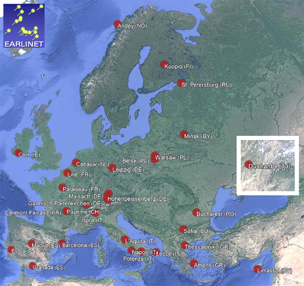
Map of the distribution over EUROPE of the active EARLINET stations updated at 14/12/2017; available at https://www.earlinet.org/index.php?id=121
- Laser probing of turbid media for optical tomography applications
- Thomson scattering Lidar diagnostics of thermonuclear plasma
- Advanced microwave propagation modeling in coastal and maritime zones
- Gamma-ray single-sided sensing and tomography of dense optically-opaque media


| Close window | Top |